Ohio might not be the first place that comes to mind when you think of jaw-dropping natural scenery, but from April through early June, the state transforms into something genuinely spectacular. Waterfalls run at full force, forest floors explode with wildflowers, and migrating birds fill the trees with sound.
Whether you prefer an easy stroll or a moderate challenge, there is a trail here that will surprise you. Pack your boots and get outside before summer heat and crowds show up.
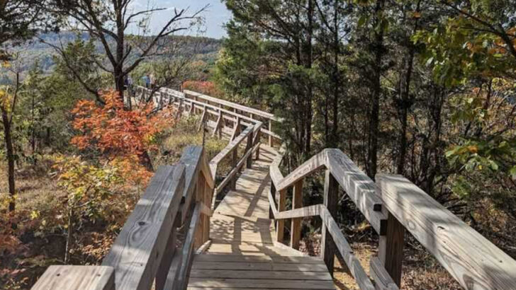
Hocking Hills State Park — Old Man’s Cave and the Gorge Trail Loop
Standing at the lip of Cedar Falls in April, you can actually feel the mist on your face from twenty feet away — that is how hard the water is moving. The Gorge Trail loop connecting Old Man’s Cave to Cedar Falls covers about six miles round trip and threads through some of the most dramatic sandstone scenery in the entire Midwest.
Black Hand sandstone walls rise on both sides, carved into arches and recess caves over millions of years.
April is the sweet spot for this trail. The waterfalls are running at their heaviest volume, and the slopes above the gorge are covered in blooming trillium, making the contrast between the dark rock and white flowers genuinely striking.
Crowds are lighter than in summer, and the air in the gorge stays cool and damp even on warmer days.
One fun fact worth knowing: Cedar Falls is surrounded entirely by hemlock trees, not cedars. Early settlers simply got it wrong, and the name stuck for over two centuries.
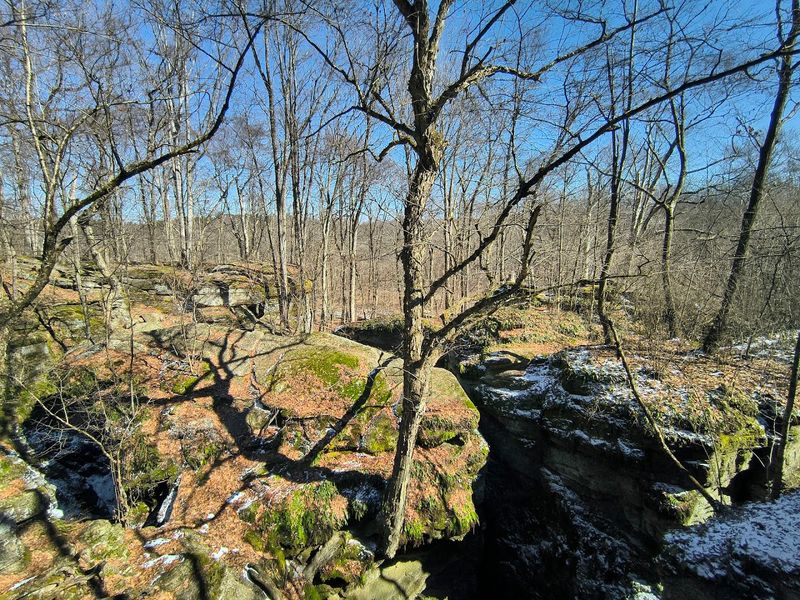
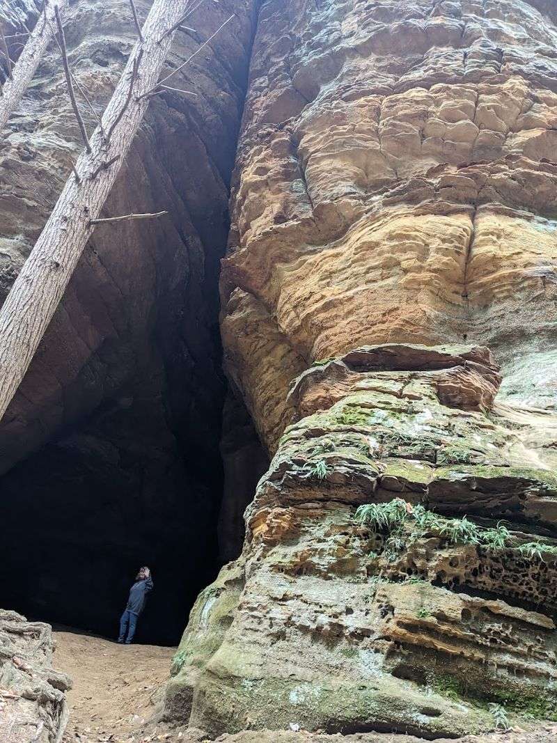
Conkle’s Hollow State Nature Preserve — A Narrow Gorge with 200-Foot Walls
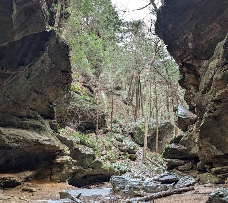
Imagine walking into a canyon so narrow that the sky above you shrinks to a thin blue ribbon — that is the Conkle’s Hollow experience, and it never gets old no matter how many times you visit. The gorge floor trail is easy and flat, running about a mile round trip through a corridor of towering Sharon sandstone walls.
A second, more demanding rim trail climbs above the canyon and opens up views across the surrounding forest canopy.
Late April is the moment to be here. Wildflowers carpet the gorge floor, and the contrast between the enclosed rock walls and the bursting spring color creates a scene that feels almost theatrical.
The moisture trapped in the gorge keeps plants blooming longer than they would on open hillsides.
Look closely at the sandstone walls and you will spot names and initials carved by visitors going back to the 1800s. The name Conkle itself comes from W.J.
Conkle, who carved his name and the date 1797 directly into the rock — making him the preserve’s most permanent guest.
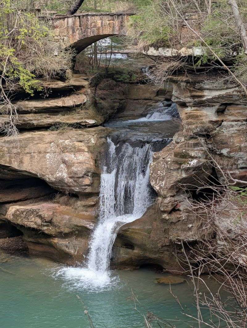
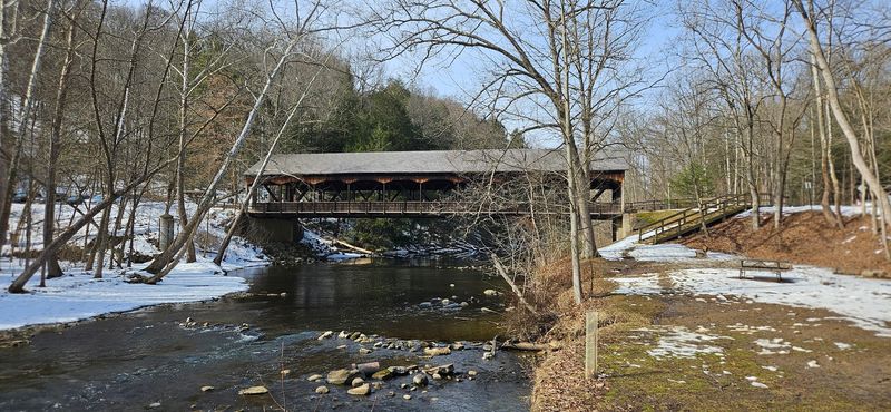
Cuyahoga Valley National Park — Brandywine Falls and the Towpath Trail in Spring
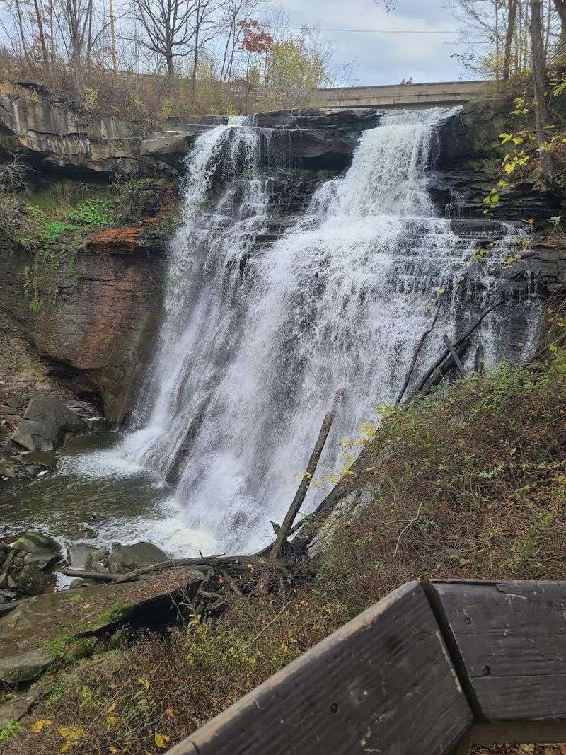
Ohio’s only national park sits between Cleveland and Akron, and most people drive right past it without realizing what is inside. Brandywine Falls drops 65 feet over a sandstone and shale ledge, and the boardwalk trail that loops around it is one of the easiest impressive waterfall hikes in the state — about 1.5 miles with minimal elevation gain.
Spring runoff in April pushes the falls to their most photogenic volume.
The Ohio and Erie Canal Towpath Trail runs through the heart of the park along the Cuyahoga River, and April turns it into a wildlife corridor worth paying attention to. Great blue herons stake out fishing spots along the bank, returning warblers fill the trees, and the first spring wildflowers push up along the canal edges.
You can walk as little or as much as you want on the towpath.
Here is the part of the story most visitors do not know: the Cuyahoga River famously caught fire 13 times between 1868 and 1969. Today it supports otters, beavers, and over 60 fish species — one of the most remarkable environmental turnarounds in American history.
Mohican State Park — Hemlock Forest, a Clear River, and Spring Warblers Moving Through
Walking into the Clear Fork gorge at Mohican State Park feels like stepping into a different climate zone entirely. The temperature drops noticeably within just a few steps as you move from the warm upland forest into the cool, hemlock-lined gorge — a microclimate so distinct that you can feel it on your skin before you even register what changed.
These hemlocks survived because the gorge walls were too steep for logging crews to work profitably.
May is the month to visit. The hemlocks flush with soft new growth, giving the dark evergreen canopy a surprisingly bright green edge, and migrating warblers use the gorge as a travel corridor on their way north.
Birders who time it right can rack up impressive species counts on the Lyons Falls Trail alone.
The Clear Fork gorge is one of the deepest river gorges in Ohio, and it sees a fraction of the visitors that Hocking Hills does despite being equally dramatic. If you want the hemlock-and-waterfall experience without the parking lot chaos, Mohican is the answer most people have not found yet.
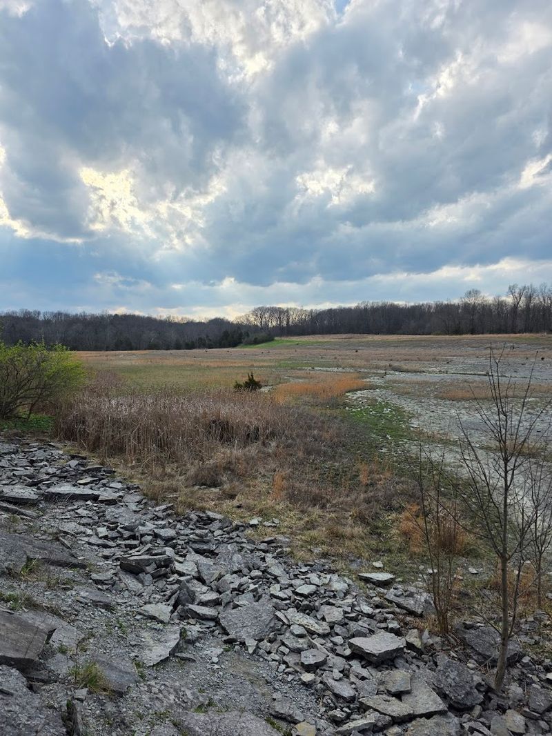
Shallenberger State Nature Preserve — A Small Hill, a Sea of Wildflowers, Almost No One Else
Not every great spring hike in Ohio requires a long drive to Hocking County. Shallenberger State Nature Preserve in Fairfield County covers just 88 acres, but in late April it pulls off something remarkable: a simultaneous bloom of fire pinks, wild ginger, trout lilies, bloodroot, and multiple trillium species all competing for attention on the same hillside.
Few places in central Ohio pack this much color into this small a footprint.
The trail system totals about two miles, making this an accessible outing even for casual hikers or families with younger kids. The short distance also means you can slow down, crouch next to flowers, and actually look at what is growing without feeling like you are falling behind a group.
The secret behind the wildflower density is the geology. Shallenberger’s quartzite bedrock creates soil chemistry that differs sharply from the limestone-dominated landscape surrounding it, supporting plant species that simply do not appear in most other central Ohio natural areas.
When Hocking Hills is packed with spring break visitors, this little preserve is quietly doing something just as beautiful with almost no audience.
Nelson-Kennedy Ledges State Park — Boulders, Slot Canyons, and Cold Air in May
Nelson-Kennedy Ledges is the kind of park that catches people completely off guard. From the parking lot it looks like a modest wooded area, but within five minutes you are squeezing through passages with names like Fat Woman’s Peril and the Squeeze, wedging between Sharon conglomerate boulders that have been tumbling and stacking here for millions of years.
The whole experience feels more like an obstacle course than a nature walk, in the best possible way.
The Icebox is the standout feature. Cold air pools permanently between two massive boulders, trapped by the rock mass overhead, and the temperature inside can run 20 degrees cooler than the surrounding trail.
In May, you can walk from warm spring air and blooming wildflowers at the trail entrance into near-freezing conditions within about thirty seconds.
The park covers roughly 167 acres in Portage County and the trail system runs about three miles total. It is compact enough to do in a half day, but the boulder maze is dense enough that you will want to slow down and explore every passage you can find.
Bring a light layer even in warm weather.
Clifton Gorge State Nature Preserve — A Fast River, Carved Limestone, and Native Plants
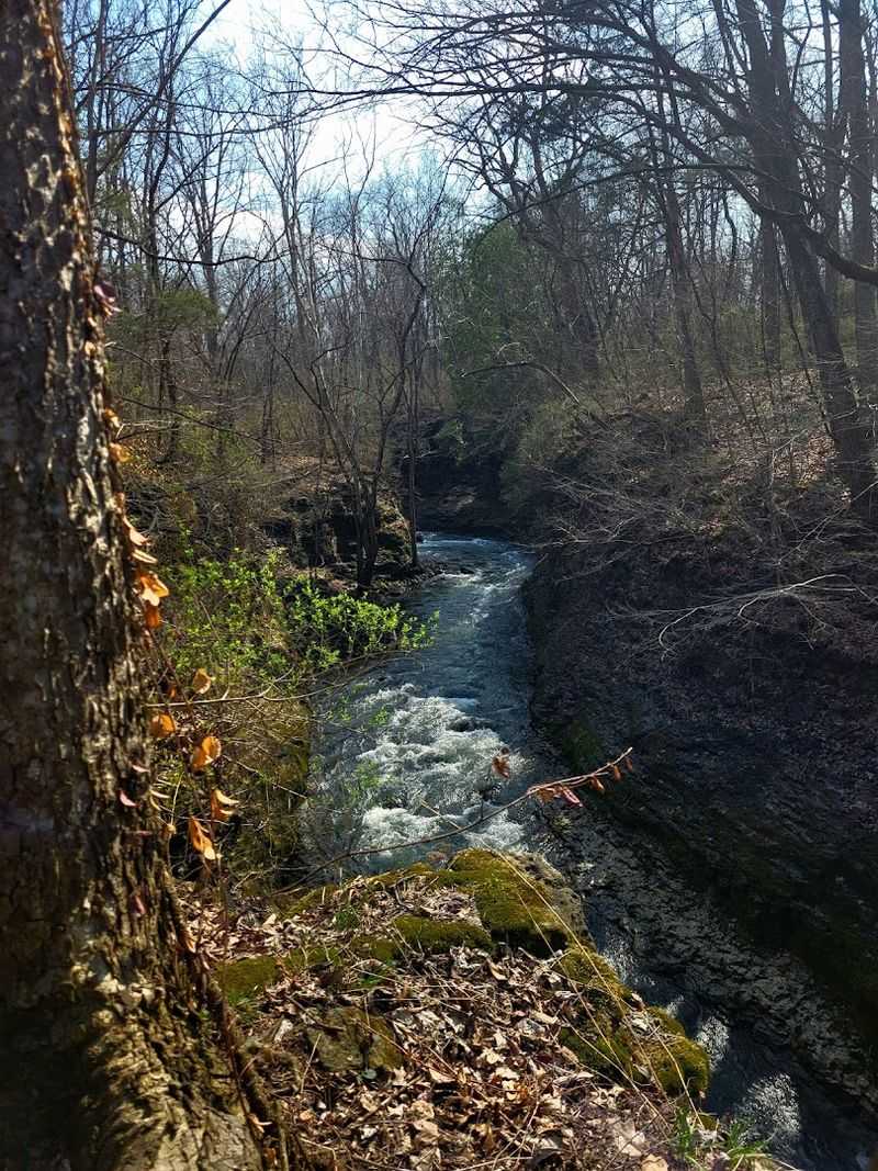
The Little Miami River does not meander gently through Clifton Gorge — it moves fast, dropping through a tight limestone canyon and carving undercut ledges that expose rock laid down roughly 440 million years ago during the Silurian period. Standing on the gorge trail with the river rushing below and limestone walls rising on both sides, it is genuinely hard to believe this place exists in Greene County, Ohio.
Spring is the right season because the north-facing slopes inside the gorge hold moisture longer than exposed hillsides, creating conditions where wildflowers persist weeks past their normal peak. Wild columbine hangs off the limestone ledges in vivid orange-red, cliff-brake fern clings to the rock faces, and American yew — a plant with no business growing this far south — survives in the cool microclimate near the river.
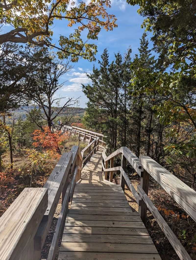
Botanists have been studying this site since the 1800s, and it was designated a National Natural Landmark for good reason. Connecting the Clifton Gorge trail to John Bryan State Park next door gives you a longer loop of two to five miles depending on your route, with the gorge section being the clear highlight.
Caesar Creek State Park — Fossil Hunting on a Trail That Doubles as a Streambed
Caesar Creek might be the only trail in Ohio where the ground you are walking on is also a legitimate fossil hunting site — and where picking up what you find is completely legal. The gorge trail follows an exposed limestone streambed where Ordovician-era marine fossils erode continuously out of the rock: brachiopods, bryozoans, horn corals, all washing free from sediment deposited when Ohio sat under a shallow tropical sea near the equator about 450 million years ago.
Spring is the ideal window. High water from winter snowmelt and April rains scrubs the streambed clean and exposes fresh fossil surfaces, but by the time the trail is accessible again the summer crowds have not yet arrived.
You get the best fossil conditions and the most elbow room at the same time.
The gorge trail runs about five miles in Warren County, and the collecting rules are straightforward: hand collection only, no tools, reasonable personal quantities. Kids absolutely love this trail because the reward for paying attention is something you can actually take home.
It turns a hike into a hands-on geology lesson that no classroom can replicate.
Crane Hollow State Nature Preserve — Old-Growth Forest and Spring Ephemerals on a Quiet Trail
Spring ephemerals are plants that run the entire arc of their above-ground life in about six weeks, blooming, seeding, and going dormant before the forest canopy closes overhead and shades them out. Crane Hollow in Hocking County is one of the best places in Ohio to watch this happen.
The combination of spring seeps, north-facing slopes, and undisturbed soil creates near-perfect conditions for hepatica, Dutchman’s breeches, trout lily, and bloodroot to appear simultaneously on the hollow floor.
The preserve covers 474 acres and the trail runs about three miles through mature second-growth forest that feels genuinely quiet — this is not a destination that shows up on most people’s radar, which means you often have the hollow to yourself during peak bloom. That solitude makes the experience feel more intimate than busier wildflower sites.
Timing a visit to Crane Hollow is part science and part luck. Mid-April gives you the best statistical chance at peak bloom, but the window shifts by a week or two depending on how cold the winter ran.
That unpredictability is exactly what makes it worth marking your calendar and checking conditions before you go.
Buzzardroost Rock — A Ridgeline View Above the Ohio River, Wild Turkey Country
The name alone should get your attention. Buzzardroost Rock sits at the end of a 2.5-mile trail through mixed oak forest in Adams County, and when you step out onto the exposed quartzite outcrop at the end, you get one of the longest open views in southern Ohio — south across the Ohio River valley and into Kentucky, with ridgeline after ridgeline rolling away in both directions.
May is the month that makes this hike worth the drive. Spring migration is moving through the Edge of Appalachia Preserve, the forest is in that perfect early-leaf state where you can see into the canopy but color is everywhere, and wild turkeys are gobbling from the ridges around dawn loudly enough to hear from the trailhead.
Arriving early means you might have the rock to yourself for sunrise.
The Edge of Appalachia Preserve surrounding this trail has recorded over 100 breeding bird species and more native plant species per acre than almost anywhere else in Ohio — a meeting point where northern and southern plant communities overlap in ways that make botanists and birders come back year after year. The round trip runs about five miles total.
Headlands Dunes State Nature Preserve — Lake Erie’s Shoreline, Undeveloped and Windy
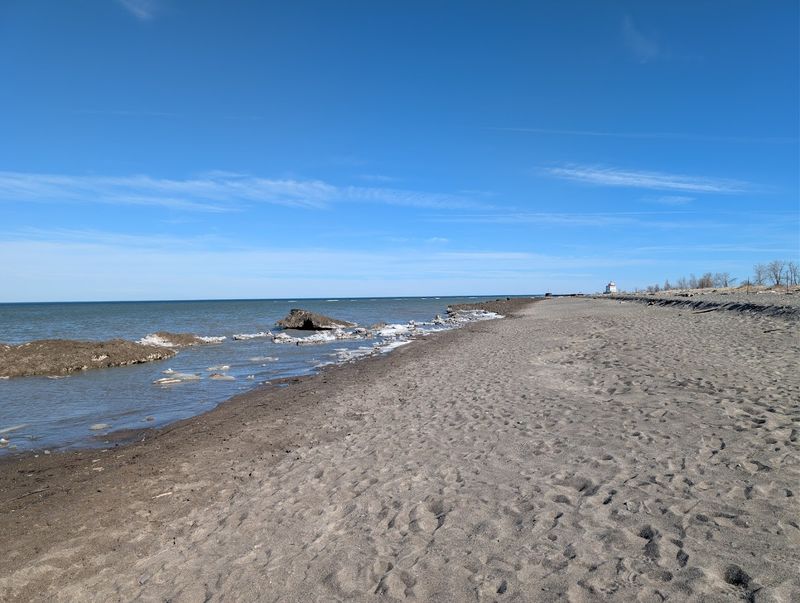
Most of Lake Erie’s Ohio shoreline has been developed, built over, or turned into marina parking. Headlands Dunes in Lake County is the exception — a narrow strip of sand dune, beach grass, and open Lake Erie beach that sits largely unchanged next to Headlands Beach State Park at the northeastern corner of the state.
Walking the short dune trail in early May, with the lake wind cutting across the open water and no crowds in sight, feels like finding a forgotten piece of Ohio coastline.
The real draw in May is the bird migration. This peninsula acts as a funnel point where warblers, shorebirds, and raptors moving north along the lake concentrate before crossing open water.
On a good migration morning in early May, the trees and shrubs at Headlands can be loaded with dozens of warbler species moving through in a single day — one of the best warbler-watching spots in the entire state.
The trail itself is only about 1.5 miles, making this one of the shorter outings on this list. But the combination of Lake Erie scenery, spring migration, and genuine solitude before summer beach season kicks in makes it worth every mile of the drive to Lake County.