There’s something special about a hike that saves its biggest surprise for the very end. In Virginia’s far southwest corner, a forest trail winds through fresh spring greenery, where wildflowers peek from the understory and birdsong drifts through the cool mountain air.
The walk feels peaceful and familiar at first, with long views and quiet stretches that encourage you to slow down and enjoy the journey.
Then the landscape changes.
Tucked atop Clinch Mountain, The Great Channels reveal a maze of towering sandstone crevices, narrow passageways, and weather-shaped rock walls unlike anywhere else in the state. In May, when the woods are lush and temperatures are comfortable, the contrast feels even more remarkable.
It’s the kind of place that invites exploration, rewards curiosity, and lingers in your memory long after the hike is over.
Here are the sights and experiences that make this destination so unforgettable.
A Natural Labyrinth of Ancient Stone
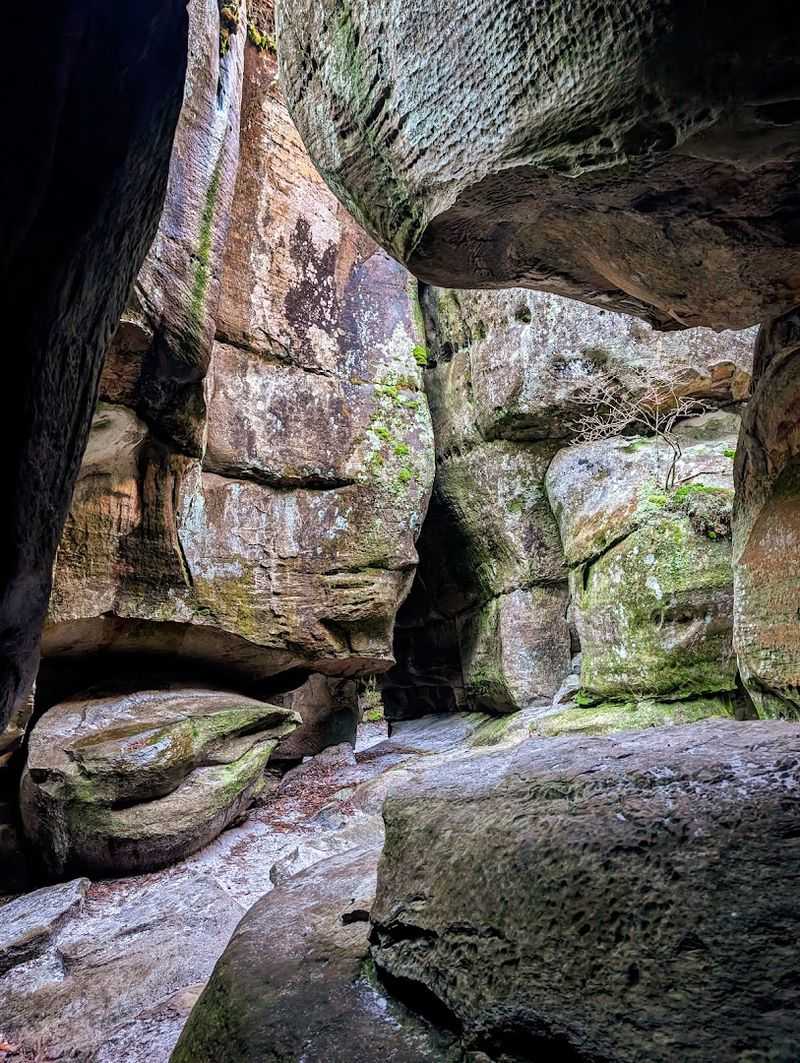
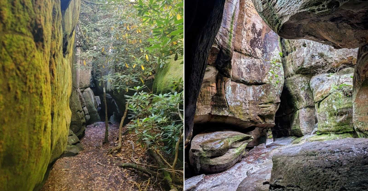
Imagine wandering through corridors carved by time itself, where towering sandstone walls rise above you like the ruins of some forgotten giant’s castle. This is what awaits at the summit of your journey.
The rock formations twist and turn in ways that seem almost impossible, creating a natural playground that feels more like Arizona than Appalachia.
These massive boulders didn’t appear overnight. They’ve been slowly weathering and separating for thousands of years since the last ice age.
The result is a 20-acre wonderland where you can squeeze through narrow gaps, climb over smooth stone surfaces, and discover new passages around every turn.
What makes this place truly special is how it challenges your sense of direction. You might find yourself turning left, then right, ducking under an overhang, only to pop out somewhere completely unexpected.
Some passages are wide enough for several people, while others require you to turn sideways.
Families love exploring here because there’s no single correct path. Kids especially enjoy the adventure of choosing which way to go next.
Just remember to pay attention to where you entered so you can find your way back out of this enchanting stone maze.
The Challenging Climb to the Summit
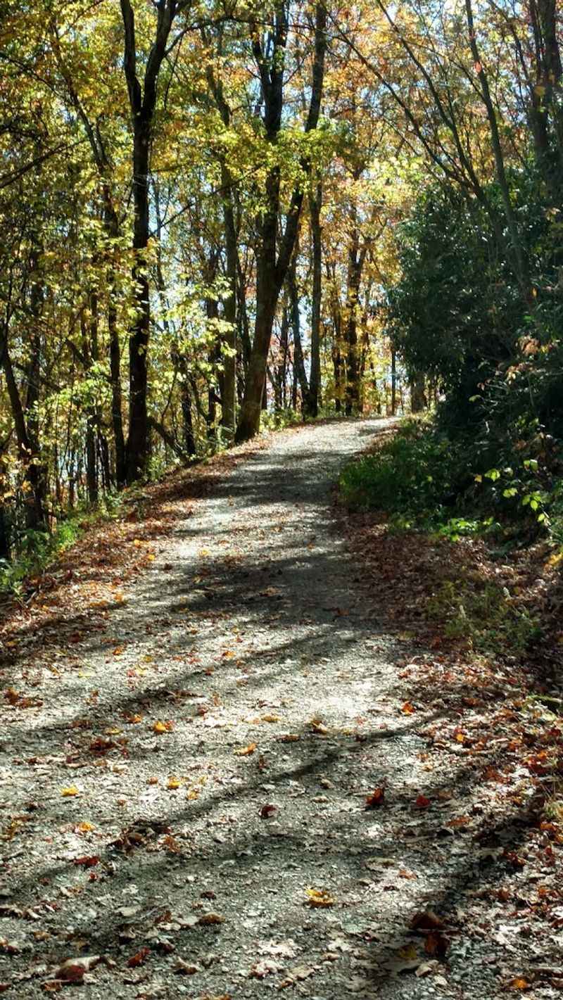
Your legs will definitely know they’ve worked by the time you reach the top. The path stretches roughly three and a half miles from the trailhead, gaining elevation steadily as you wind your way up Clinch Mountain.
Most of the route follows an old gravel road, making the footing predictable and stable under your boots.
The first section feels gentle and manageable. You’ll settle into a comfortable rhythm as you pass through mixed hardwood forest.
But don’t let that easy start fool you into thinking the whole hike will be a breeze.
As you climb higher, the grade becomes noticeably steeper, especially in that final mile. Your breathing gets heavier and your calves start to burn a little.
This is where having water and taking breaks becomes important. Fortunately, plenty of rocks along the way offer perfect spots to pause and catch your breath.
The beauty of this uphill challenge is that gravity becomes your friend on the return trip. Coming back down feels almost effortless compared to the ascent.
Many hikers report the descent takes nearly half the time, turning what was once a workout into a pleasant cooldown that gives your knees a different kind of exercise.
The Historic Sentinel Fire Tower
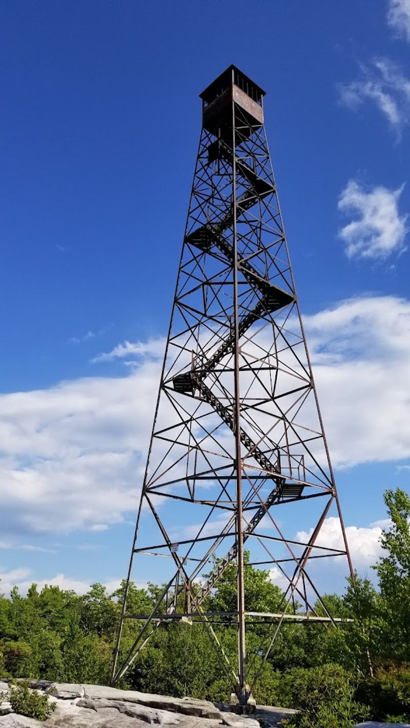
Standing like a weathered guardian near the channels, an old fire tower tells stories of a different era. Built in 1939 by Franklin Roosevelt’s Civilian Conservation Corps, this structure once served as a vital watchpoint for forest fires across the region.
Workers would climb to the top daily, scanning the valleys and ridges for any signs of smoke during the fire tower’s operational years.
The tower remained in service for over three decades before being retired in 1970. Modern technology eventually made these mountaintop sentinels obsolete.
Today, the lower steps have been removed for safety reasons, so climbing is no longer possible, but the structure still stands proud as a reminder of conservation history.
Reading the historical marker near the base gives you perspective on how much effort went into protecting these forests. The CCC workers who built it hauled materials up this same mountain you just climbed.
Their legacy remains in the stonework and metal framework that has withstood decades of harsh mountain weather.
Many visitors pause here to rest before continuing to the channels themselves. The tower marks an important waypoint, signaling you’re close to your destination and offering a tangible connection to the past that enriches your overall experience on the mountain.
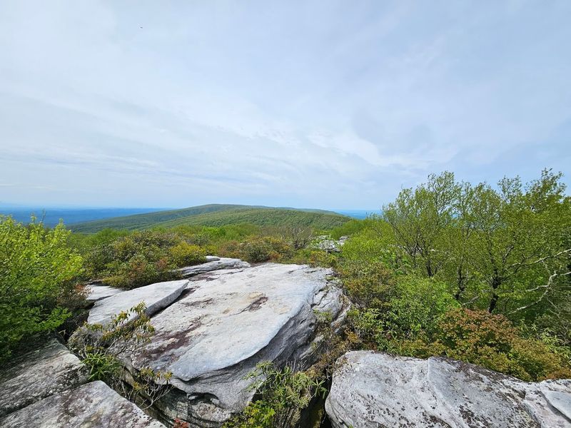
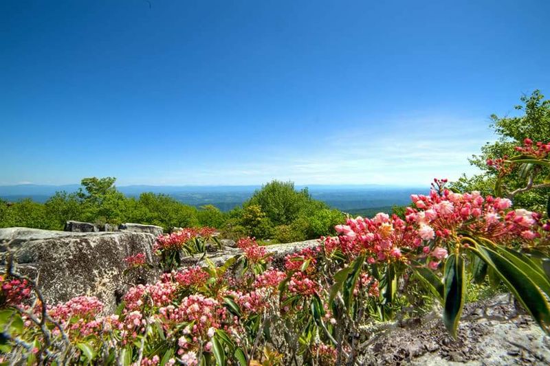
Breathtaking 360-Degree Mountain Views
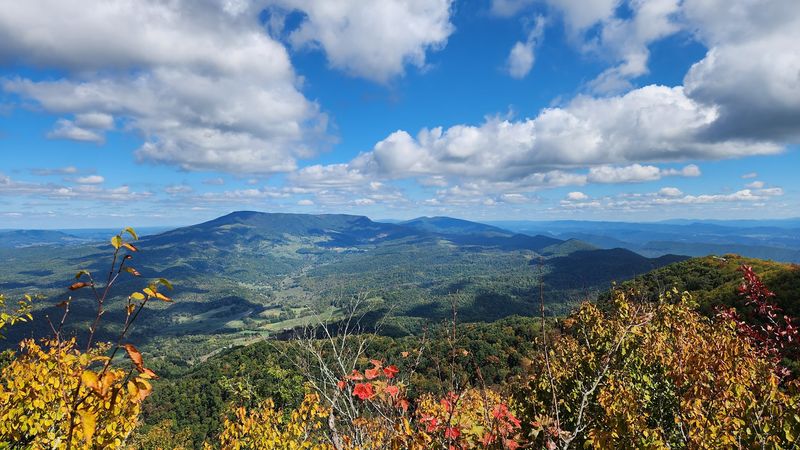
Few moments compare to that first glimpse when you emerge from the tree line and the world opens up around you. Mountains roll away in every direction like waves frozen in time, ridge after ridge fading into misty blue distances.
The elevation here puts you above most surrounding peaks, creating an almost aerial perspective of Southwest Virginia’s rugged landscape.
On clear days, you can see for miles and miles. The valleys below look like miniature worlds, with tiny farms and winding roads creating patterns across the green quilt of forests and fields.
It’s the kind of view that makes you want to spin slowly in a circle, taking in each compass direction.
The rock formations themselves create natural viewing platforms. You can carefully climb atop some of the larger boulders to gain even better vantage points.
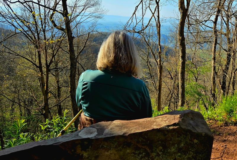
Many hikers spread out their packed lunches here, enjoying their hard-earned meal while soaking in the scenery that surrounds them.
Photography enthusiasts go crazy for these views, especially during fall when the forest canopy explodes with color. Sunrise and sunset cast particularly dramatic light across the landscape.
Even on overcast days, something magical happens when clouds drift through the valleys below while you stand above them in sunshine.
The Ten-Spot Parking Puzzle
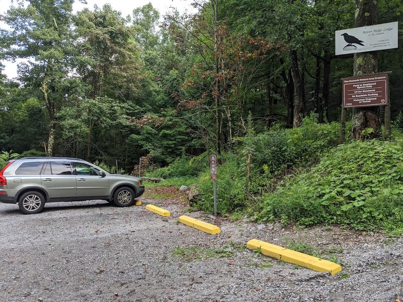
Here’s where planning becomes absolutely essential to your visit. The trailhead offers exactly ten numbered parking spaces.
Not eleven, not twelve—just ten. This limitation stems from the preserve’s location at the end of a private road where additional parking simply isn’t available or permitted.
Signs make it crystal clear that parking outside designated spots will result in your vehicle being towed. The warning isn’t idle either—enforcement does happen.
This means timing your arrival strategically makes the difference between starting your hike immediately or turning around disappointed after a long drive.
Weekday mornings before 10 AM offer your best chance at snagging a spot. Saturday and Sunday mornings fill up incredibly fast, sometimes by 8 AM during peak seasons like fall foliage time or perfect spring weather weekends.
Late afternoons as other hikers return can open up opportunities, though you’ll need to account for having enough daylight to complete your own hike.
Carpooling with friends isn’t just environmentally friendly—it’s practically mandatory here. Groups arriving in one vehicle instead of three make room for other adventurers.
Some visitors coordinate arrival times through social media or local hiking groups, creating a community solution to this natural bottleneck challenge.
Slot Canyon Vibes in Appalachia
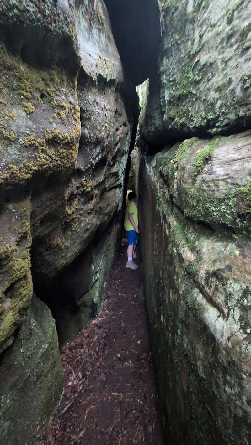
Walk between these towering stone walls and you’d swear you were somehow transported to Utah or Arizona. The formations bear striking resemblance to the famous slot canyons of the American Southwest, which makes discovering them in Virginia feel like stumbling onto a geographic secret.
Narrow passages force you to turn sideways in spots, while overhead the sky becomes a ribbon of blue squeezed between stone.
The similarity isn’t entirely coincidental. Both locations feature sandstone shaped by millennia of weathering, though the processes that formed them differ significantly.
These rocks fractured during freeze-thaw cycles over thousands of years, while Southwestern slots were carved primarily by flash floods through softer stone.
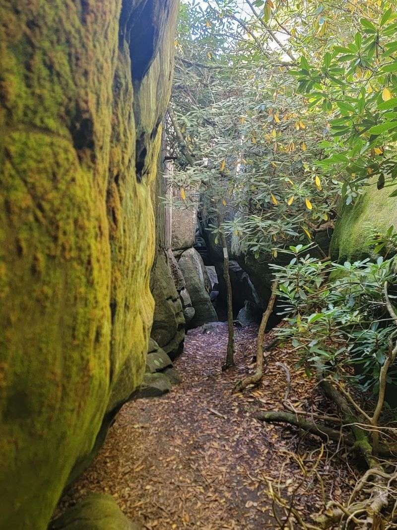
Light plays tricks here just like in Western canyons. Sunbeams angle down through gaps, illuminating patches of moss and ferns that cling to the shadowy spaces.
The temperature drops noticeably once you step into the deeper channels, offering welcome coolness on hot summer days.
This unexpected landscape draws photographers who want shots that defy expectations of what Virginia looks like. Visitors from Western states often remark on the uncanny similarities while locals take pride in having such unique geology right in their backyard without needing to travel across the country.
Protected Natural Area Preserve Status
What you’re visiting isn’t just a random hiking spot—it’s officially designated as one of Virginia’s Natural Area Preserves. This special status means the land receives protection specifically because of its rare geological features and ecological significance.
The state recognizes the channels as irreplaceable, worthy of conservation for future generations to experience and study.
This designation comes with responsibilities for visitors. The preserve operates under specific rules designed to minimize human impact.
Pack out everything you pack in. Stay on established trails where they exist, and step carefully when exploring the rock formations themselves.
The 721-acre preserve encompasses far more than just the channels themselves. It protects the entire surrounding ecosystem on this high-elevation ridgetop.
Rare plant species that thrive in these specific conditions depend on the habitat remaining intact and undisturbed by excessive foot traffic or careless behavior.
Virginia’s Department of Conservation and Recreation manages the property, balancing public access with preservation needs. Operating hours from 6 AM to 5 PM help control usage while allowing most visitors reasonable access.
This careful management ensures the channels will continue to amaze hikers for decades to come, maintaining the same wild character that makes this destination so special and memorable.
A Moderate Physical Challenge Worth Accepting
Nobody’s going to mistake this for an easy neighborhood stroll. The hike earns its moderate rating honestly, demanding real physical effort without crossing into extreme difficulty.
If you can handle stairs and aren’t completely sedentary, you can probably manage this trail with proper pacing and preparation.
That steady uphill grade tests your cardiovascular fitness and leg strength. Your heart rate will climb along with the elevation.
Many first-timers underestimate the cumulative effect of three miles of gradual ascent, expecting something easier than what they encounter.
Smart hikers bring plenty of water—at least two liters per person. Dehydration turns a manageable challenge into a miserable experience fast.
Snacks help maintain energy levels, especially for the exploration time you’ll want at the top. Proper footwear matters too; hiking boots or sturdy trail shoes prevent slips and provide ankle support.
The physical investment pays incredible dividends though. Reaching the channels after earning them through effort makes the experience more meaningful than if you could simply drive up.
Your body releases endorphins from the exercise, enhancing the natural high of discovering such an amazing place. Plus, you’ll burn enough calories to guilt-free enjoy a celebratory meal afterward without thinking twice about dessert.
An Explorer’s Playground at the Peak
Once you arrive at the channels, a sense of childlike wonder takes over. The structured trail disappears and suddenly you’re free to choose your own adventure through this geological playground.
There’s no map to follow through the maze, no arrows pointing which direction to go next—just pure exploration guided by curiosity and a sense of discovery.
Some passages lead to dead ends requiring you to backtrack and try another route. Others open unexpectedly into small chambers or connect to different sections entirely.
You’ll find yourself naturally drawn to squeeze through narrow gaps just to see what’s on the other side or to climb up and over smoother sections of rock that offer different perspectives.
Groups often split up temporarily, each person following their own intuition through the maze before reuniting to share what they found. Kids absolutely thrive in this environment, finally somewhere their natural inclination to climb, explore, and investigate is not only allowed but encouraged.
Adults rediscover similar joys they may have forgotten since childhood.
Budget at least an hour for exploring, though many visitors spend two or three hours wandering the channels before reluctantly beginning their descent. There’s always one more passage to check, one more boulder to climb, one more angle to photograph before you feel ready to leave this remarkable place behind.
Seasonal Beauty and Perfect Timing
Each season paints the channels and surrounding forest with completely different character. Spring arrives late at this elevation, but when it does, rhododendrons burst into spectacular bloom, their pink and white flowers creating tunnel-like displays along parts of the trail.
Wildflowers carpet the forest floor, and everything feels fresh and renewed after winter’s dormancy.
Summer brings full green canopy overhead, offering shade on the hike up while the channels themselves stay remarkably cool. This natural air conditioning makes hot July and August days perfect for exploration.
Watch out for mosquitoes though—bug spray becomes essential equipment during these months.
Fall transforms the experience entirely. The hardwood forest explodes with color as maples, oaks, and hickories shift through brilliant yellows, oranges, and reds.
The mountain views become even more dramatic with this seasonal palette. Weekends in October bring the biggest crowds as leaf-peepers flock to witness the show.
Winter hiking is possible but requires extra caution. Ice can make the rocks dangerously slippery, and snow obscures the trail in places.
However, brave cold-weather adventurers are rewarded with solitude and a stark beauty that’s equally impressive. The bare trees open up views that summer foliage blocks completely, offering different photographic opportunities throughout the year.