You are about to meet a West Virginia rail trail that quietly delivers big mileage, bigger scenery, and the kind of calm you will talk about for years. The Greenbrier River Trail runs 77 miles along an old 1900 railroad, crossing 35 bridges and slipping through two tunnels with only a gentle grade.
Pack your gravel bike, hiking shoes, or a fishing rod and you are set for shaded miles alongside emerald water. Keep reading for smart tips, mile-by-mile highlights, and the practical details that make a great trip effortless.
Trail Overview and Rail-Trail History
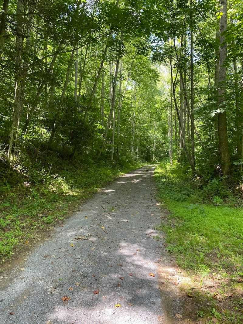
The first thing you notice is how easy the miles melt away. Built on a 1900 railroad grade, the Greenbrier River Trail runs a forgiving 77 miles with only a gentle grade, perfect for long rides and steady hikes.
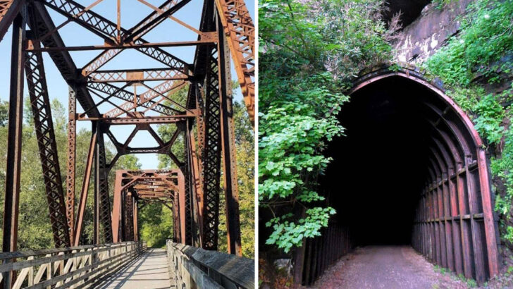
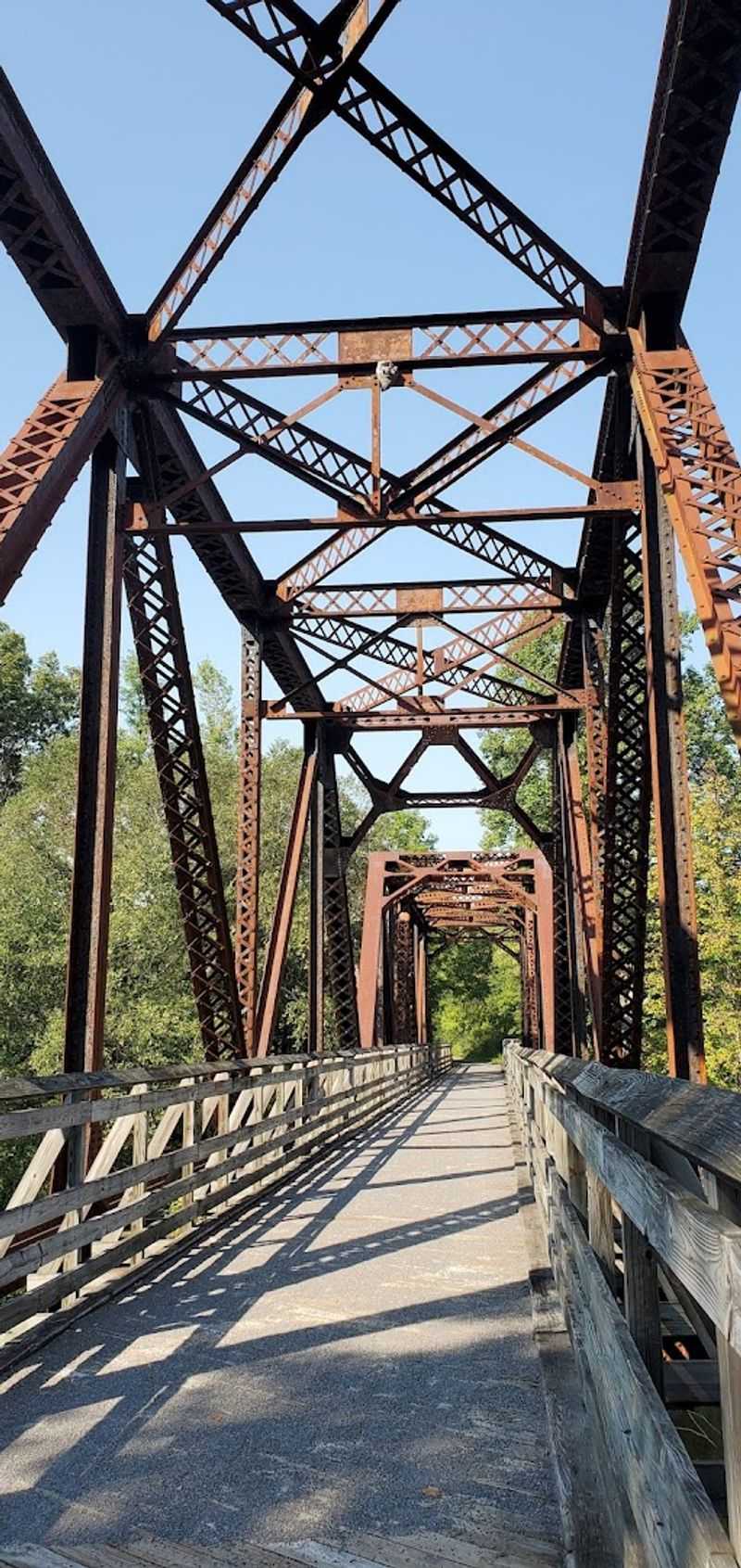
Thirty five bridges and two tunnels stitch together quiet valleys, small communities, and sweep after sweep of river views.
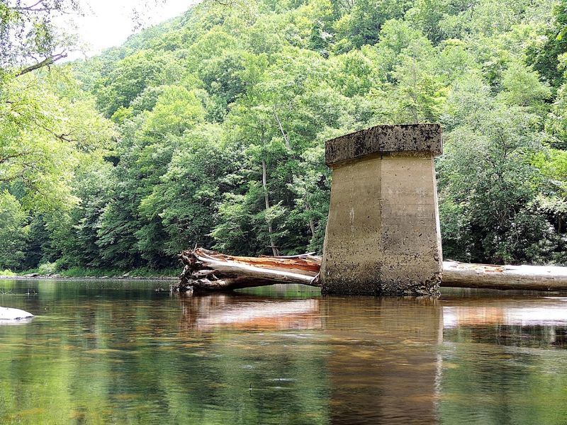
History is not a plaque here, it is the alignment itself. Timber and coal once moved this corridor, and now it moves you past ferny cuts and stonework that still shows hand-laid craft.
When the trains stopped, local advocates saved the corridor, and West Virginia State Parks now stewards it as a year-round route for biking, hiking, and horseback riding.
Expect packed gravel, mostly shaded stretches, and long periods with only birds and water as company. Cell service is spotty, which is part of the charm, so download maps and carry basic gear.
If 77 miles sounds big, break it into approachable days linked by trailheads, campsites, and water pumps that make point-to-point or out-and-back trips simple.
Best Sections for First-Timers
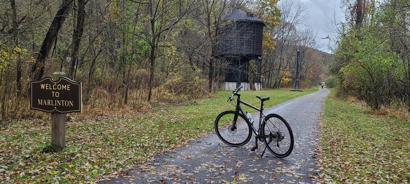
Starting simple builds confidence, so pick segments with easy logistics and big payoff. Marlinton to Seebert serves up riverside riding, wildlife sightings, and a few paved miles before turning to well-graded gravel.
Another friendly sampler runs Anthony north toward Renick, with broad views, picnic spots, and minimal traffic at road crossings.
If a tunnel sounds fun, focus on the approach to Droop Mountain Tunnel from Renick. The grade is still mellow, yet the atmosphere tightens into cool stone and echoing wheels, then opens back to sun and river.
Short on time, aim for 6 to 12 miles out-and-back to keep turnaround easy and pacing relaxed.
Trailheads in Marlinton and Seebert typically have parking, toilets, and posted maps, which removes guesswork. You will appreciate shaded stretches during summer and the wind protection in shoulder seasons.
Bring 40 to 60 psi tires if on a hybrid and a small light for tunnels, then add layers for cooler river air.
Biking Surface, Tires, and Gear
Packed gravel rules most of this route, with three paved miles near Marlinton and occasional cinderlike sections. You will ride happiest on 38 to 50 mm tires if using a gravel or hybrid bike, or standard mountain bike rubber if that is what you own.
Road bikes with thin slicks feel skittish and risk pinch flats.
Gearing can stay moderate given the gentle grade, but low range pays off when hauling camping gear. A simple toolkit, spare tube, pump, and quick links solve the most common issues far from towns.
Toss in chain lube because crushing miles through fine grit will dry a drivetrain faster than expected.
Brakes should be well tuned for damp mornings and tunnel approaches. Lights are smart in the two tunnels and at dusk under heavy tree cover.
Hydration, sun protection, and a lightweight layer matter, since riverside shade can flip to cool air quickly even in late spring and fall.
Hiking and Trail Running Tips
Feet love the predictable grade and gentle surface here. Long walks from Anthony or Marlinton keep you close to water and wildlife, while compact out-and-backs make pacing simple for families.
Runners will appreciate minimal elevation change that supports negative splits on the return.
Expect toe numbing shade in autumn and spring mornings, so start in a light jacket and stash it later. Gaiters are unnecessary, but wool socks handle damp crossings and sneaky puddles from spring seepage.
On hot days, early starts beat heat, and every shaded mile along the river buys extra comfort.
Trail etiquette is straightforward: stay right, announce passes, and give equestrians extra space. Because cell coverage fades in pockets, share your route with a friend or snap a photo of the map board at the trailhead.
Pack a simple first aid kit, water filter, and snacks to reduce bailout pressure if schedules slip.
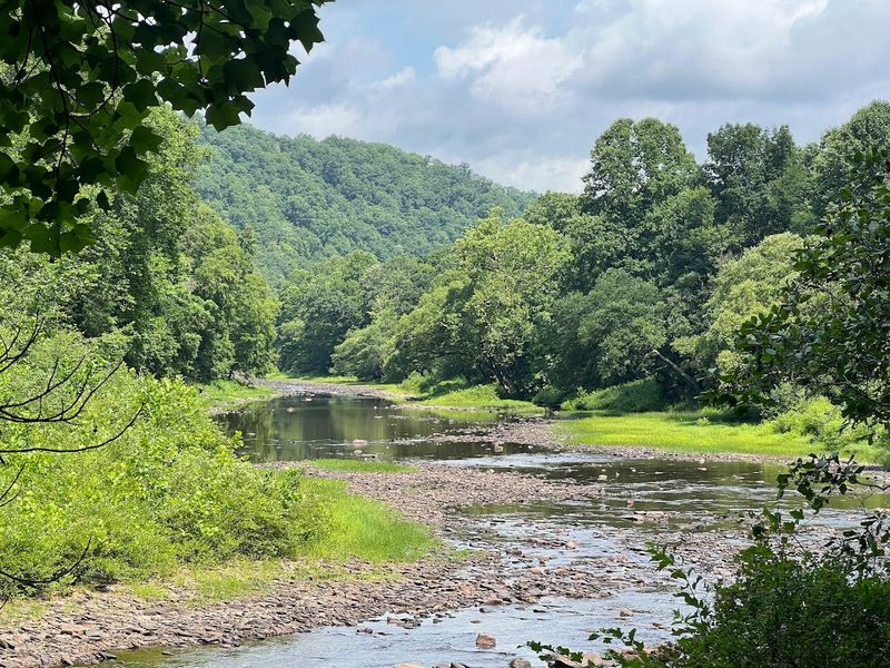
Bridge Highlights and River Views
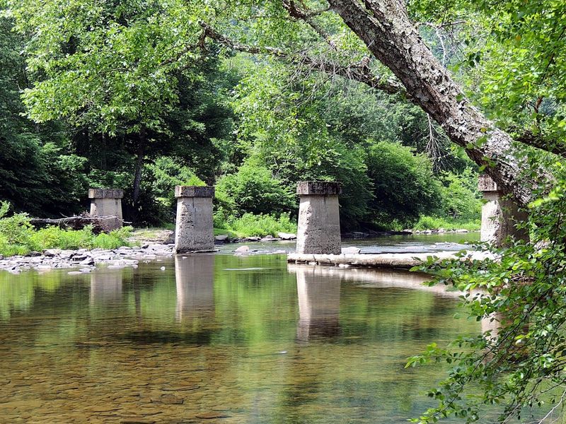
Bridges arrive like punctuation, each one re-centering your eyes on silvered water and long corridors of forest. Some are petite spans with wood decking and iron railings, others are proud trusses that frame the river like a postcard.
You will count dozens across 77 miles, enough variety to keep momentum lively without breaking rhythm.
Angles matter for photos, so step to the downstream side for softer reflections and symmetry. Late afternoon light warms steel and brings out textures in old riveting and stone abutments.
On calm days, fishermen work eddies below, and you can linger long enough to hear the fly line whisper.
Safety wise, ride predictably and avoid stopping mid span when groups are stacked. Wind can nudge bikes unexpectedly, so keep a smooth line and relaxed grip.
If water is high, treat deck boards as slick until you feel traction return, then roll on with confidence toward the next view.
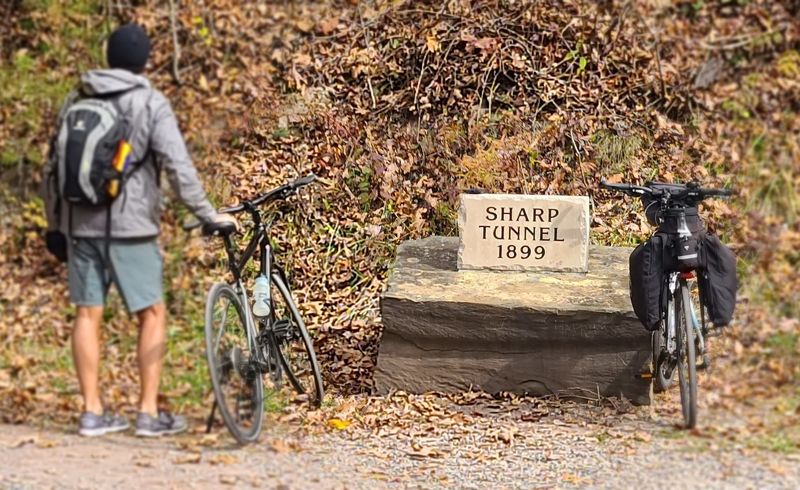
Droop Mountain Tunnel and Other Tunnels
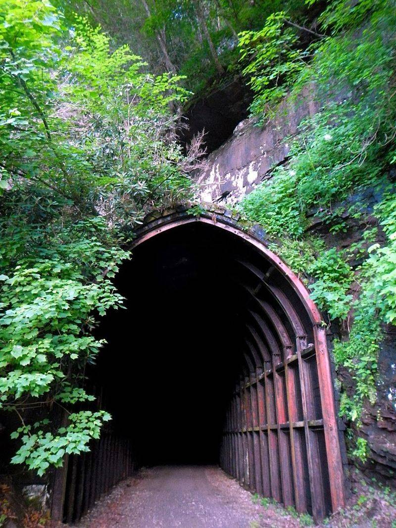
Cool air spills from the tunnel mouth like opening a cellar door. Droop Mountain Tunnel is long enough to merit a steady light, yet welcoming once your eyes settle.
The approach feels cinematic, pine and hardwood pressing close before the stone portal swallows road noise and bright day.
Tires hum differently on the enclosed surface, so hold a straight line and give space when riders bunch. Sunglasses off, light on, and a calm cadence gets you through with no drama.
The second tunnel is shorter, but warrants the same routine, especially after rain when slick patches linger.
Photos work best at the exit with backscatter light painting the mist. If kids are along, make it an event by letting them ride a few feet ahead, then regroup just outside.
Warm layers help on shoulder season rides because temperature swings can feel big between shade, tunnel air, and open riparian stretches.
Campsites, Shelters, and Overnight Strategy
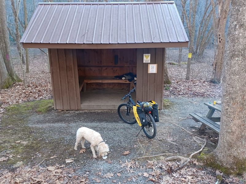
Multi day trips shine here because spacing between campsites and Adirondack shelters fits comfortable mileage. Many sites include picnic tables, fire rings, and water pumps, though you should confirm seasonal status and treat water as needed.
Quiet hours feel natural since the only background noise is river flow and night insects.
Bikepackers can aim for 25 to 40 miles per day to leave time for bridges, photos, and fishing. Hikers planning section trips should trim distances to 10 to 15 miles to keep feet fresh on gravel.
Shelters reduce packing complexity, but still carry a lightweight sleep system to handle temperature swings.
Food planning is easier if you stash dinner at a town stop or pre arrange a vehicle shuttle. Bear canisters are not required, yet odor control and hanging food away from shelters show good backcountry manners.
Morning coffee by the river has a way of stretching schedules, so start earlier than you think you need.
Access Points, Parking, and Shuttles
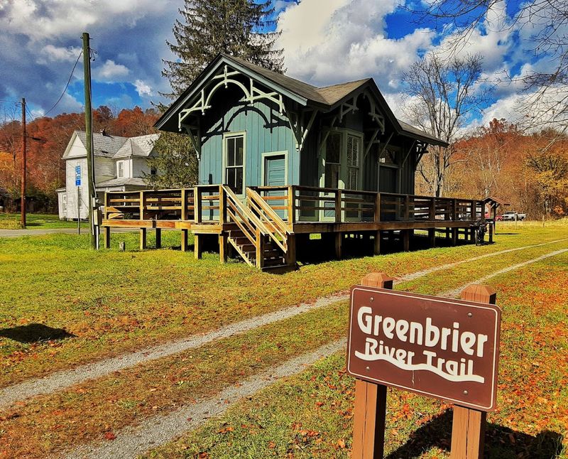
Reaching the corridor is straightforward once you pick a segment. Popular access points include Marlinton, Seebert, Renick, Anthony, and Cass, each with varying parking and amenities.
The main address listed for Greenbrier River Trail is 4800 Watoga Park Rd, Marlinton, with details on the state parks website and posted boards at trailheads.
Point to point travel feels effortless if you arrange a shuttle through local outfitters or roll two cars. Many riders prefer out-and-backs to simplify logistics, using mileposts for pacing and turnaround goals.
Weekends fill faster during foliage season, so arrive early to secure a spot and to enjoy cooler air.
Bathrooms and water pumps appear at intervals, but they are not at every lot, so plan ahead. GPS can be glitchy in mountains, making downloaded maps or screenshots of directions surprisingly valuable.
Display a day plan on your dashboard and keep valuables out of sight to keep focus on the ride.
Seasons, Weather, and What to Wear
Seasonality changes the personality of this trail without breaking its rhythm. Spring brings wildflowers and fast water, with chilly mornings that reward gloves and a wind layer.
Summer turns the canopy into a shady corridor and makes river breaks irresistibly refreshing.
Autumn may be the crowd favorite thanks to fiery color and crisp air that sharpens views across bridges. Expect cooler temperatures in shaded cuts and near tunnels, so pack a beanie or neck gaiter even on sunny forecasts.
Winter riding is very doable on dry days, but watch for freeze thaw soft spots on gravel.
Clothing wise, think breathable layers you can shed. A lightweight rain shell, merino base, and full finger gloves cover most scenarios.
Shoes with decent tread help on slick decking, and a compact towel earns its keep after a spontaneous wade or drizzle.
Wildlife, Fishing, and Leave No Trace
Expect company from deer, wild turkey, songbirds, and the occasional groundhog scurrying across the corridor. The river itself is a steady invitation for anglers targeting smallmouth bass and trout in cooler tributary-fed stretches.
You can pedal with a travel rod strapped to the frame, then slip down to a gravel bar between miles.
Leave No Trace keeps the experience for the next visitor. Pack out all trash, keep fires in designated rings, and go easy on vegetation at river access points.
Human waste should be handled at toilets where available or at proper cathole distance well away from water.
Wildlife photos work best with patience instead of pursuit. Give fawns and nesting birds space, leash dogs near busy areas, and announce passes to avoid startling hikers.
If you see high water or muddy banks, choose durable surfaces and accept a shorter detour rather than carving fresh tracks.