
Cumberland Island sits just off Georgia’s coast like a secret waiting to be discovered. Most people think of Georgia beaches as crowded and commercial, but this barrier island tells a completely different story with wild horses, mysterious ruins, and surprising military secrets from the Cold War era.
Getting there requires a ferry ride, but once you step onto the island, you enter a world where history and nature blend together in unexpected ways. From hidden bunkers to mansion ruins and untouched beaches, this national seashore offers adventures that most visitors never knew existed.
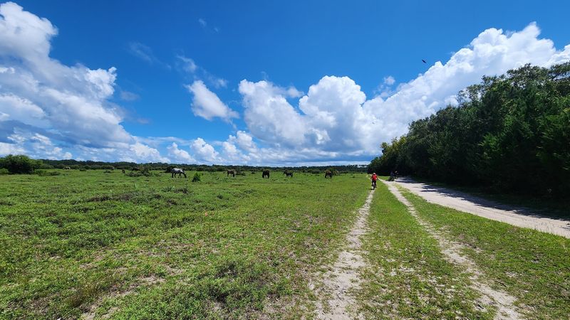
Wild Horses Roaming Ancient Maritime Forest Trails
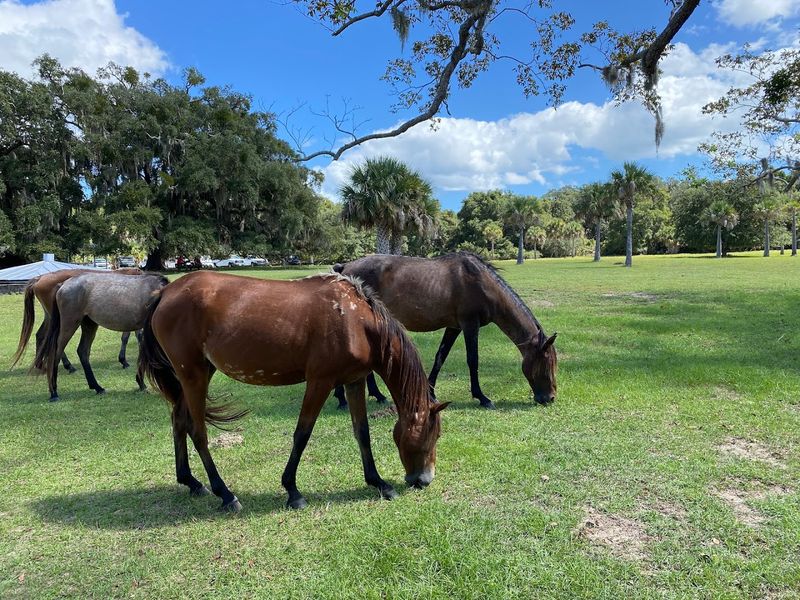
Over 150 wild horses call Cumberland Island home, and spotting them along the forest trails creates magical moments you won’t forget. These feral descendants of horses brought by Spanish missionaries centuries ago roam freely through the island’s 9,800 acres.
You’ll find their hoofprints and droppings everywhere, which means an encounter is almost guaranteed if you explore the wooded paths.
The horses seem to prefer the shade of massive live oaks draped with Spanish moss, especially during hot summer days. They graze peacefully near the Dungeness ruins and along the main road connecting the north and south ends.
Rangers remind visitors to keep at least 40 feet away because these animals are wild and can kick or bite if approached.
Early morning walks offer the best chances for horse sightings before other visitors arrive on later ferries. Bring a good camera with a zoom lens to capture their beauty without getting too close.
The contrast of dark horses against white sand dunes or standing beneath ancient trees makes for stunning photographs.
Many families return to Cumberland Island specifically hoping to see these magnificent creatures. Their presence adds an element of wilderness adventure that makes the island feel truly untamed and special compared to typical beach destinations.
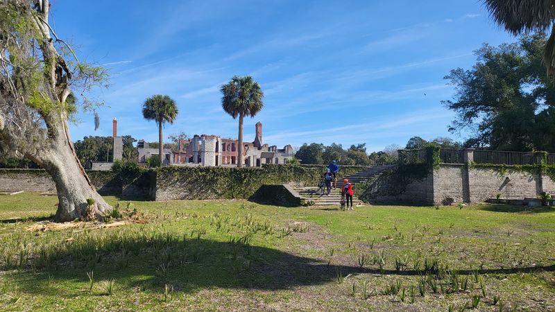
Dungeness Ruins Tell the Carnegie Family Story
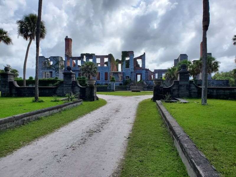
Walking through the Dungeness ruins feels like stepping into a Southern Gothic novel where nature reclaims human ambition. Steel magnate Thomas Carnegie and his wife Lucy built this massive mansion in 1884 on the site of a Revolutionary War general’s home.
The 59-room estate once represented the height of Gilded Age luxury with formal gardens, fountains, and servants’ quarters.
Fire destroyed the mansion in 1959, leaving behind dramatic tabby and brick walls standing four stories tall. Wild horses now graze where wealthy industrialists once hosted elaborate parties.
The crumbling chimneys and empty window frames create hauntingly beautiful photo opportunities, especially during golden hour when sunlight streams through the skeletal structure.
Volunteer rangers often station themselves near the ruins to share fascinating stories about the Carnegie family’s island dynasty. Lucy Carnegie eventually owned 90 percent of Cumberland Island and built additional mansions for her children.
Her determination to preserve the island’s natural beauty ironically helped protect it from development that consumed other Georgia barrier islands.
A short walk from the Sea Camp dock brings you to these magnificent ruins accessible to all ferry visitors. Information plaques explain the mansion’s history and the wealthy family whose legacy still shapes the island today.
First African Baptist Church Historic Legacy
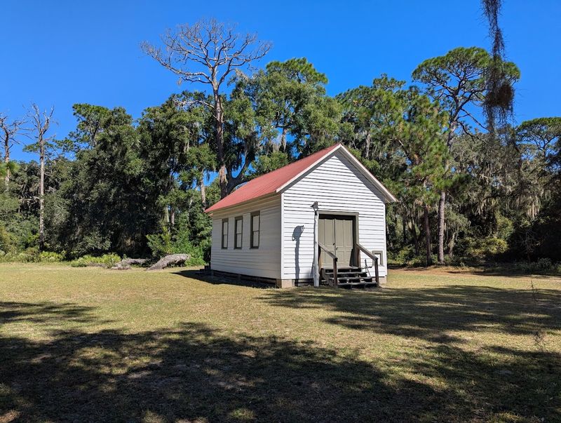
Tucked away in the island’s northern reaches stands a small white church that witnessed one of modern history’s most famous weddings. First African Baptist Church was established in the 1890s by formerly enslaved people who stayed on Cumberland Island after the Civil War.
This simple wooden structure represents the resilience and faith of the Gullah Geechee community that called this island home.
John F. Kennedy Jr. and Carolyn Bessette chose this remote church for their secret 1996 wedding ceremony.
Only about 40 guests attended, making it one of the most private celebrity weddings ever held. The island’s isolation and restricted access made it perfect for avoiding media attention.
Today, the church sits quietly among live oaks accessible only by guided tour or a long bike ride from the main ferry dock. Its whitewashed exterior and simple interior remind visitors that Cumberland Island’s history includes more than wealthy Carnegie estates.
The surrounding settlement area once thrived with homes, farms, and community life.
Reaching the church requires significant planning since it’s located about 6 miles north of the Sea Camp dock. Many visitors take the van tour that includes stops at both Plum Orchard mansion and this historic church, learning about the island’s complex social history.
Plum Orchard Mansion’s Preserved Grandeur
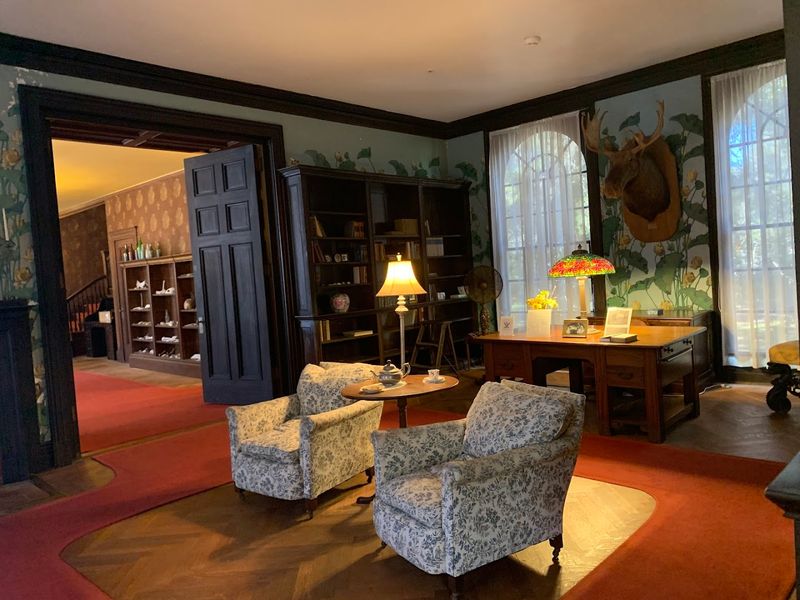
Few visitors expect to find a 30-room Georgian Revival mansion still fully furnished sitting in the middle of a wilderness island. Lucy Carnegie built Plum Orchard in 1898 as a wedding gift for her son George and his wife Margaret.
Unlike the burned Dungeness ruins, this mansion survived remarkably intact with original furniture, artwork, and decorative elements still in place.
Walking through Plum Orchard’s rooms feels like traveling back to 1898 when the Carnegie family summered here. Ranger-led tours take you through elegant parlors, the formal dining room, and upstairs bedrooms where you can see period furniture exactly where the family left it.
The mansion’s isolation protected it from vandalism and theft that might have occurred in a more accessible location.
From 1971 to 2003, the mansion actually served as a seasonal home for National Park Service workers. This continued occupation helped preserve the building’s structure and contents.
The Parks Service now offers scheduled tours during peak season, though you must plan ahead since ferry schedules and walking distances make spontaneous visits challenging.
Reaching Plum Orchard requires either a 6-mile bike ride or joining a paid van tour from the Sea Camp dock. The effort rewards you with one of America’s most unique historic home tours set within a protected wilderness.
Cold War Military Remnants Hidden in Plain Sight
Most visitors focus on wild horses and Carnegie mansions, completely missing the island’s Cold War military history hiding among the trees. During World War II and into the Cold War era, the U.S.
Navy maintained facilities on Cumberland Island for testing and surveillance purposes. Concrete bunkers, radar foundations, and military infrastructure still dot the landscape for those who know where to look.
The Navy constructed several installations on the island’s northern end during the 1950s and 1960s. These facilities monitored submarine activity off the Atlantic coast and tested new military technologies.
When the bases closed, nature began reclaiming the structures, creating eerie concrete ruins that contrast sharply with the island’s natural beauty.
Some bunkers are accessible via backcountry trails, though they’re not marked on standard tourist maps. Experienced hikers who venture into the wilderness areas sometimes stumble upon these overgrown remnants of America’s Cold War paranoia.
The concrete structures now shelter wildlife rather than military equipment, offering unexpected discoveries for curious explorers.
Rangers occasionally share stories about the island’s military past during interpretive programs at Sea Camp. This lesser-known chapter of Cumberland Island history adds another layer to its already complex story spanning Native American settlements, Spanish missions, plantation era, Gilded Age wealth, and modern conservation efforts.
Northern Wilderness Area’s Backcountry Trails
Beyond the day-tripper zones, Cumberland Island’s northern wilderness area offers true backcountry experiences few Georgia destinations can match. This designated wilderness zone covers thousands of acres where development never occurred and nature remains essentially unchanged.
Hiking here requires permits, planning, and a willingness to disconnect from modern conveniences completely.
Primitive campsites scattered throughout the wilderness area provide shelter for overnight backpackers. These spots offer no facilities beyond a cleared space for your tent, making them perfect for people seeking genuine wilderness solitude.
You’ll carry all your water, food, and supplies since nothing exists beyond what you bring on your back.
Trails wind through dense maritime forests where palmetto understory grows so thick you might feel like you’re in a jungle. The lack of other people creates opportunities to observe wildlife behaving naturally without human interference.
Deer, wild turkeys, armadillos, and countless bird species thrive in these protected areas far from the day-use zones.
Reaching the wilderness area typically requires hiking or biking 10-12 miles from the Sea Camp ferry dock. Most wilderness explorers spend 2-3 days camping to make the journey worthwhile.
This commitment filters out casual visitors, ensuring those who make the trek enjoy genuine solitude on one of the East Coast’s last undeveloped barrier islands.
Eighteen Miles of Undeveloped Atlantic Beaches
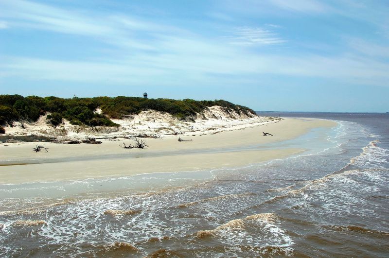
Imagine walking for miles along a pristine beach without seeing a single hotel, restaurant, or souvenir shop. Cumberland Island’s 18-mile Atlantic coastline remains completely undeveloped, offering beach experiences that disappeared from most of America’s coast decades ago.
White sand, rolling waves, and scattered shells create scenes that look more like Caribbean islands than southeastern U.S. beaches.
The beach runs the entire length of the island from north to south, providing endless walking opportunities. During weekdays in spring or fall, you might wander for hours seeing only a handful of other people.
This solitude feels almost impossible to find on modern beaches where development crowds every available space with high-rise condos and beachfront businesses.
Swimming is allowed, though the brownish water doesn’t look as inviting as the crystal-clear Caribbean. The Atlantic Ocean’s natural color here results from tannins leaching from vegetation and sediment from nearby rivers.
Despite its appearance, the water is safe for swimming, and lifeguards are not present since the island maintains its wild character.
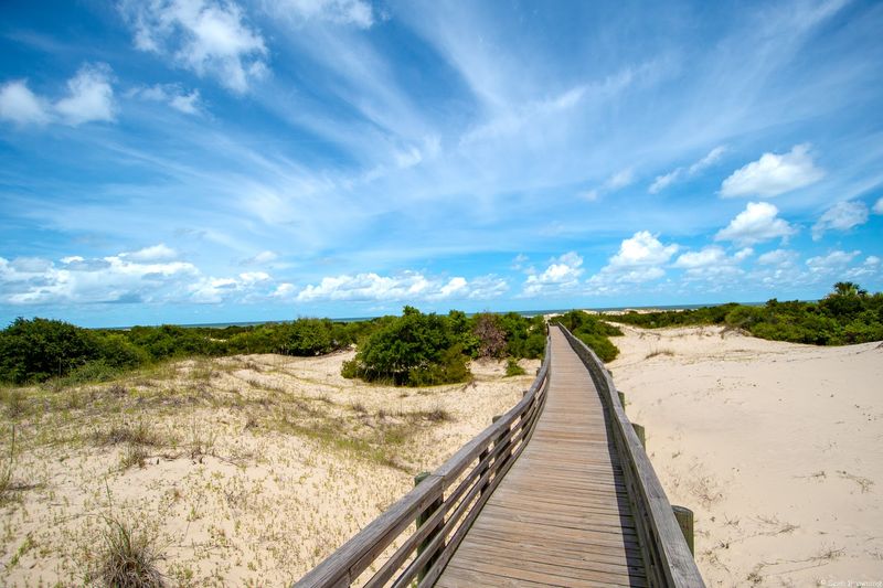
Reaching the beach from the Sea Camp dock requires a 15-20 minute walk through maritime forest and dunes. Boardwalks help protect fragile dune ecosystems while providing easier access than trudging through deep sand.
Bring everything you’ll need since no facilities, vendors, or services exist once you’re on the beach itself.
Sea Camp Dock Gateway to Island Adventures
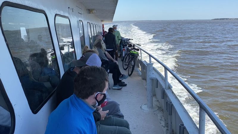
Your Cumberland Island adventure begins the moment you step off the ferry onto the Sea Camp dock. This main visitor area serves as the island’s nerve center where rangers provide orientation talks, restrooms offer last chances for modern plumbing, and information boards display trail maps.
Everything you need to know about navigating the island can be found in this small developed area before you venture into the wilderness.
Rangers typically give a short orientation speech when each ferry arrives, explaining island rules and offering safety tips. They emphasize keeping distance from wild horses, bringing adequate water, and respecting the Leave No Trace principles that keep this place pristine.
Asking questions here saves confusion later when you’re miles from help on a remote trail.
The Sea Camp area includes a small visitor center with exhibits about island ecology and history. Park rangers sell books, maps, and souvenirs, though selection is limited compared to typical tourist destinations.
Water filling stations provide the last chance to top off your bottles before heading toward the beach or ruins.
Many first-time visitors underestimate the walking distances involved and return to Sea Camp exhausted and dehydrated. The dock sits about a mile from the Dungeness ruins and even farther from the beach.
Planning your time and energy carefully ensures you can actually enjoy what you came to see rather than spending your visit recovering from poor preparation.
Salt Marsh Boardwalks and Maritime Forest Paths
Between the ferry dock and the Dungeness ruins, elevated boardwalks carry you through salt marsh ecosystems teeming with life. These wooden walkways protect fragile marsh grasses while letting you observe coastal wildlife up close without disturbing their habitat.
Herons, egrets, and other wading birds feed in the shallow waters while fiddler crabs scurry across exposed mud at low tide.
The boardwalk offers wheelchair accessibility, making Cumberland Island’s beauty available to visitors who couldn’t navigate sandy trails or beaches. Interpretive signs along the route explain salt marsh ecology and the important role these wetlands play in coastal ecosystems.
You’ll learn how spartina grass stabilizes shorelines and provides nursery habitat for countless marine species.
Connected to the boardwalks, shaded trails wind through maritime forests dominated by massive live oak trees. Spanish moss drapes from branches creating a mystical atmosphere that photographers love.
These forest paths provide welcome relief from the intense sun that beats down on open beaches and dune areas during summer months.
Walking these varied trails showcases the island’s incredible habitat diversity within just a few miles. You’ll transition from salt marsh to maritime forest to freshwater wetlands, each supporting different plant and animal communities.
This ecological variety helps explain why Cumberland Island earned protection as a National Seashore worthy of preservation for future generations to explore and study.
Historic Stafford Plantation and Tabby Ruins
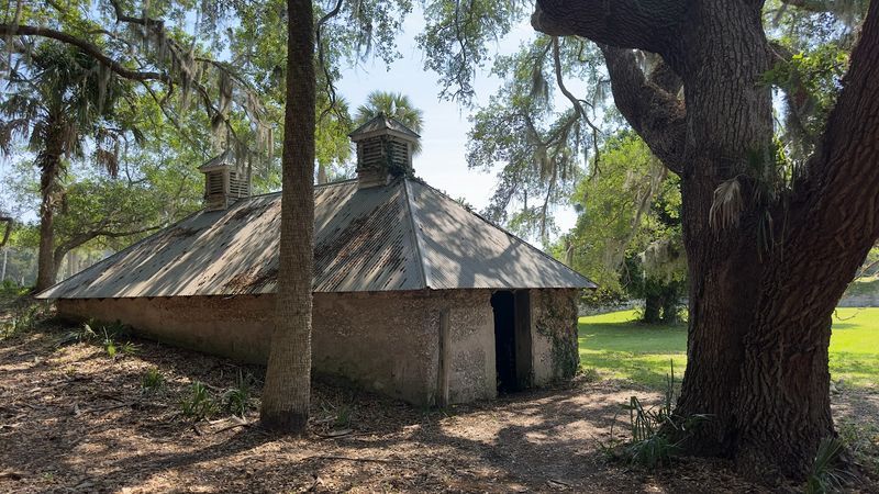
Before the Carnegie family created their Gilded Age paradise, Cumberland Island supported plantation agriculture using enslaved labor. Stafford Plantation ruins and the adjacent cemetery tell this darker chapter of island history that predates the mansions most visitors come to photograph.
Tabby structures made from oyster shells, lime, and sand still stand as reminders of Georgia’s plantation economy.
General Nathanael Greene, a Revolutionary War hero, originally developed this plantation in the late 1700s. After his death, various owners continued operating the plantation through the antebellum period.
The crumbling tabby walls you see today represent slave quarters, plantation buildings, and other structures that supported this agricultural operation.
The nearby cemetery contains graves of enslaved people and their descendants who lived and died on Cumberland Island. Simple markers and indigenous plants have reclaimed much of the burial ground, creating a peaceful space that honors lives often forgotten in historical narratives.
Some descendants still visit to maintain family grave sites and preserve their ancestors’ memory.
Reaching Stafford Plantation requires a bike ride or long walk from the main visitor areas since it’s located in a less-traveled section of the island. The isolation means fewer crowds and more time for quiet reflection on the complex history that shaped Cumberland Island long before it became a protected National Seashore attracting tourists from around the world.