If you want to experience the true character of Michigan, it helps to leave the highways behind and follow its rivers.
Long before modern transportation networks existed, these waterways connected inland farms, mills, and settlements to the Great Lakes, influencing where communities were established and how local economies developed.
Today, with much of the industrial pressure of the past gone, many riverfront towns have shifted their focus toward preserving historic architecture, supporting cultural events, and expanding outdoor recreation opportunities.
Proximity to the water still shapes a distinct and more relaxed pace of daily life that cannot easily be replicated elsewhere.
The following guide highlights 10 riverfront towns in Michigan that showcase the beauty and importance of the state’s major waterways.
Together, they demonstrate how some of Michigan’s most rewarding places to explore continue to thrive along the water’s edge.
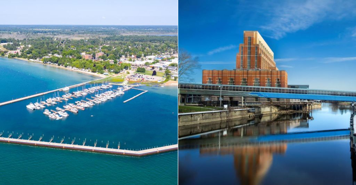
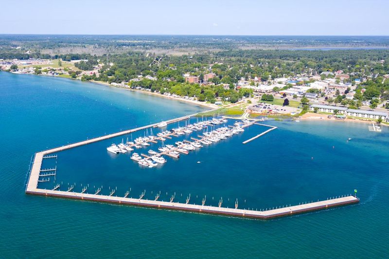
Grand Haven
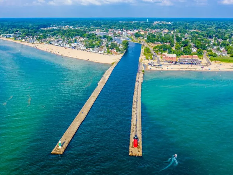
At the mouth of the Grand River, this lakefront community developed where inland trade could meet Lake Michigan shipping.
Lumber, manufactured goods, and agricultural products once moved through the harbor, and the river helped establish a busy commercial waterfront during the nineteenth century.
Its position near the lake made the channel valuable for regional transportation and for vessels serving broader Great Lakes routes.
Today, public access explains the river’s continuing importance more clearly than any single monument. Visitors can follow stretches of boardwalk and riverwalk near downtown, watch boat traffic near the municipal marina, and spend time in parks that frame the working waterway rather than hiding it.
Waterfront Stadium, Chinook Pier, and nearby green space show how civic planning preserved room for both recreation and marine activity.
Boating culture remains central here because the river is still a gateway, not just scenery.
Anglers, pleasure craft, and larger commercial movements all share a setting that connects inland Michigan with open water.
That practical relationship between river, harbor, and lake is what gave the city its lasting economic and civic shape.
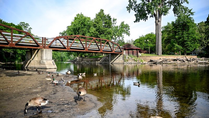
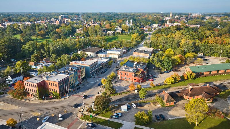
Lowell
Where the Flat River meets the Grand River, this community grew around waterpower, transportation, and access to surrounding farmland.
Early mills used the current to process grain and timber, tying local business to the riverbanks in a direct way.
That confluence also created a physical center for settlement, giving merchants and workers a practical reason to cluster near the water.
River heritage is still visible in the historic downtown and in the recreational spaces that line the banks. Anglers come for smallmouth bass and other warmwater species, while paddlers and cyclists use the area as part of a broader outdoor network.
The Riverwalk, nearby trails, and public views of both channels show how the community turned former industrial edges into shared civic space.
Water also shaped identity here through memory and routine, not only economics.
Local heritage organizations have preserved stories of milling, bridge building, and trade, while annual events often return attention to the river setting.
The result is a place where economic growth, recreation, and local history still meet at the same two waterways.
Grand Ledge
Unlike many river towns defined first by commerce, this one is inseparable from a striking geological feature.
Along the Grand River, tall sandstone ledges rise above the water and create one of the most unusual landforms in southern Michigan.
Those cliffs gave the community its name and helped make the river corridor important not only for settlement, but also for scientific and scenic interest.
Recreation now interprets that landscape in practical ways.
Kayakers and canoeists use the current for relaxed paddling, climbers study designated rock faces nearby, and hikers head to Fitzgerald Park for trails and river views.
The ledges also shape how people experience the waterfront, because the river feels enclosed, textured, and physically dramatic rather than broad and industrial.
Development here has long responded to those natural conditions.
The river supported transportation and local enterprise, yet the sandstone bluffs made preservation and park planning equally significant.
Geological character became part of civic identity, which is why outdoor activity, environmental awareness, and the river itself remain closely linked in the daily life of this community today.
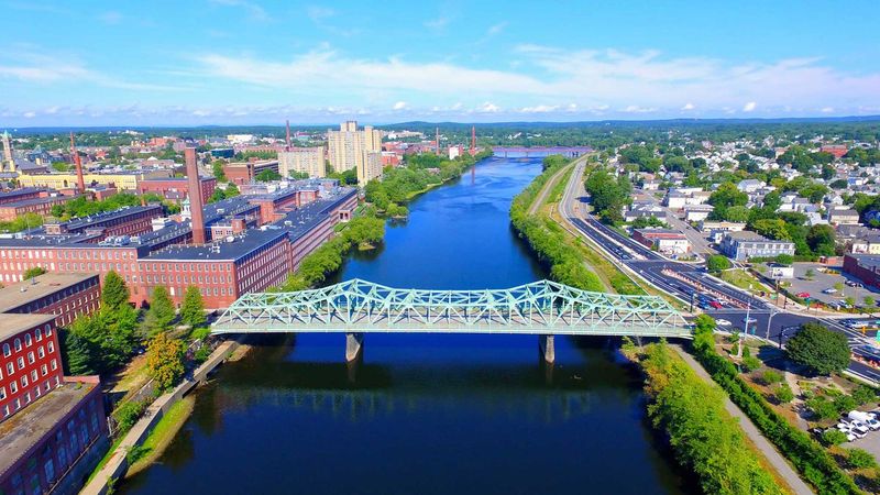
Lansing
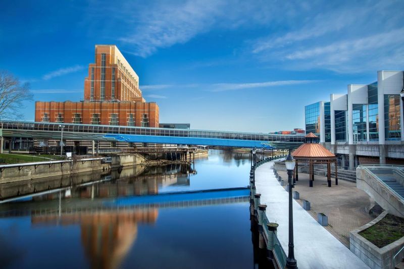
In the capital city, the Grand River shows how a historic waterway can remain relevant inside a modern government and university region.
Early settlement depended on the river corridor, even though the city later became more defined by rail connections, state institutions, and roads.
The water still provided a physical framework, and recent planning has treated it as valuable civic infrastructure rather than leftover space.
Riverfront revitalization has changed how residents use the center of the city.
The Lansing River Trail links parks, neighborhoods, and public destinations along the Grand River and the Red Cedar River, creating continuity through an otherwise fragmented urban landscape.
Adado Riverfront Park and nearby open spaces support festivals, walking, cycling, and daily recreation while restoring visibility to the channel.
That shift matters because urban rivers often reveal the priorities of a place.
Here, cleanup, access, and design have turned the waterfront into a public asset that supports health, mobility, and environmental awareness.
The river is not simply a backdrop to government buildings. It remains an organizing feature in how the capital thinks about growth and public life.
Ypsilanti
Flowing past historic commercial blocks and former industrial sites, the Huron River helped define this Washtenaw County community from its earliest growth.
Waterpower and transport encouraged milling and manufacturing, while nearby rail links later strengthened the economic role of Depot Town.
That combination made the river a working part of local industry rather than a decorative edge.
The riverfront now carries a different but still meaningful civic function.
Riverside Park provides open space for festivals and daily recreation, and Frog Island Park adds another public landscape tied closely to the water.
Paddlers, anglers, walkers, and cyclists use the Huron River Greenway to connect outdoor activity with neighborhoods, historic districts, and public gathering places.
Culture here still reflects that layered history.
Old industrial buildings, the Michigan Firehouse Museum area, and the preserved streetscape of Depot Town all sit within a broader story about how the river shaped labor, trade, and community memory. Recreation continues that relationship in a new form.
The waterway remains central because it links heritage, environmental use, and contemporary local life in one corridor.
Frankenmuth
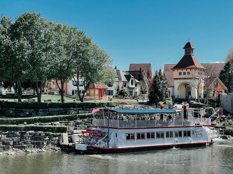
Settled by German immigrants in the nineteenth century, this community took shape beside the Cass River, where fertile land and dependable water supported farming and early development.
The river corridor helped connect the settlement to surrounding areas, even as the place became known more for ethnic traditions and tourism later on.
Water was part of the practical foundation before it became part of the visitor experience.
Today, the Cass River is visible through boat excursions, riverside green space, and walking routes that frame the town from a quieter angle than its commercial streets.
The Bavarian Belle Riverboat interprets the waterway as scenery and history at once, while nearby parks and trails give access to the bank itself.
Fishing, casual paddling, and birdwatching keep the river in everyday use.
That matters because heritage here is not only architectural.
The waterway influenced land use, settlement patterns, and the growth of a service economy tied to landscape as much as tradition.
River access also broadens understanding of the area beyond restaurants and shops. It reveals how the community grew from an agricultural river settlement into a distinctive cultural center.
Marine City
Few Michigan river communities show the scale of Great Lakes commerce as clearly as this one on the St. Clair River.
During the nineteenth century, shipbuilding and related marine trades played a major role in local growth, supported by a deep international waterway linking Lake Huron and Lake St. Clair.
The river was never merely local here. It was part of a binational shipping corridor used by vessels moving between major inland ports.
That working identity remains visible from the waterfront.
Freighters still pass close to shore, giving residents and visitors an unusually direct view of international marine traffic.
Public riverfront spaces, marinas, and downtown viewpoints keep the channel central to everyday life, while historic buildings recall the period when yards, captains, and maritime labor shaped the economy.
Cultural traditions also reflect that connection.
River watching, boating, and local storytelling all grow from long familiarity with commercial navigation and borderland exchange.
The result is a community where maritime history feels immediate rather than distant.
The St. Clair River still explains architecture, public space, and civic memory better than almost any other feature in town.
Manistee
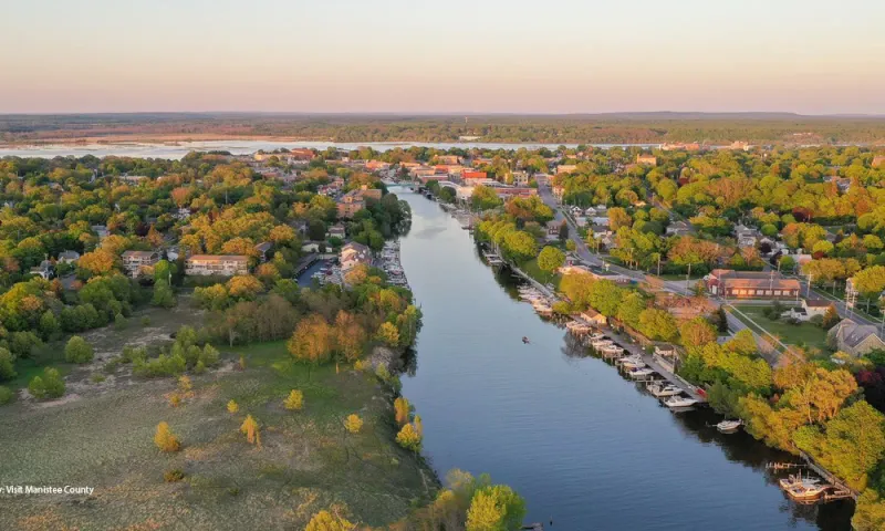
Built where the Manistee River reaches Lake Michigan, this port city grew rapidly during the lumber boom that transformed western Michigan in the nineteenth century.
Logs moved through the river system, mills clustered near the waterfront, and navigation improvements supported trade with regional and Great Lakes markets.
Catastrophic fires, including the 1871 blaze, changed the built environment, yet the river remained the economic constant.
Modern public spaces make that past easier to read.
The Riverwalk and surrounding downtown blocks place visitors near the channel that once carried timber wealth, while the North Pierhead Lighthouse marks the connection between river navigation and open lake shipping.
Fishing traditions remain strong as well, with salmon and trout drawing attention to the river’s continuing ecological and recreational value.
Preservation efforts matter here because natural resources once drove both prosperity and environmental strain.
Today, historic districts, marinas, and coastal management practices show a different relationship with the waterfront, one centered on stewardship and public access.
The river still shapes development, but now it does so through heritage interpretation, fishing culture, and careful use of a sensitive shoreline.
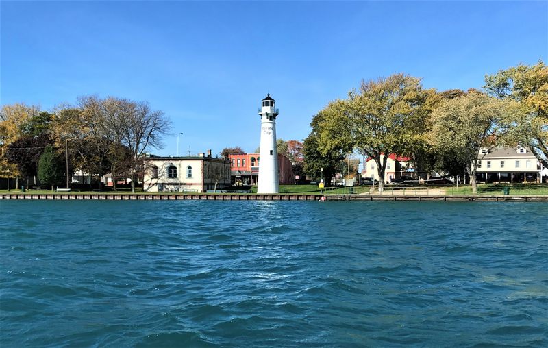
Cheboygan
Northern Michigan’s inland waterway system gives this community unusual strategic importance.
The Cheboygan River connects Mullett Lake and the chain of interior lakes to Lake Huron, creating a route that long supported transport, fishing, and recreational boating.
Because of that geography, the river has served as both local main street and regional corridor, linking inland settlements with the open Great Lakes.
Boating culture is especially visible here.
Marinas, the working drawbridge, and easy access to the Inland Waterway make the river central to summer activity, while anglers value nearby opportunities for salmon, steelhead, walleye, and other species depending on season and location.
The Cheboygan River Front Range Light and associated maritime history help explain why navigation mattered so much in this setting.
Public life still gathers around the waterfront because the channel shapes movement, business, and identity all at once.
Historic commercial areas sit close to the river, and the nearby Great Lakes context keeps marine history within everyday view.
This is a place where geography still governs how people travel, fish, dock, and understand the surrounding region.
Tawas City
Along the Lake Huron shore, this community is best understood through the relationship between smaller river systems, protected bay water, and the larger lake beyond.
The nearby Tawas River region helped shape settlement and land use, while Tawas Bay provided safer access for boating, fishing, and coastal trade than the open shoreline alone could offer.
That combination placed the town within both inland and maritime networks.
Shoreline recreation now reveals that geography clearly.
Harbor facilities, public access points, and bayfront parks support sailing, paddling, and charter fishing, while nearby state park landscapes emphasize how coastal dunes, wetlands, and river mouths work together.
Local maritime heritage is also tied to lifesaving, navigation, and commercial fishing traditions that developed along this stretch of Lake Huron.
The importance of waterways here lies in connection rather than scale.
Small tributaries fed settlement, the bay moderated exposure, and the lake opened routes to wider exchange.
Together, those features shaped everyday work and seasonal recreation in lasting ways. The result is a river and shoreline community where inland drainage and Great Lakes culture remain tightly linked.