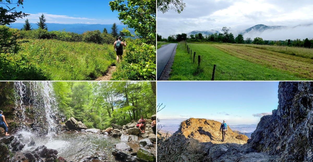
Straddling the border between North Carolina and Tennessee, Great Smoky Mountains National Park feels like a place where time moves differently, with mist drifting through valleys and ridgelines fading into soft blue distance. Winding roads and forested slopes reveal one of the most visited natural landscapes in the United States.
In May, the park feels especially alive: dogwoods and wildflowers brighten the forest floor, waterfalls run strong from spring rains, and cool mountain air carries the scent of pine and earth. Wildlife moves quietly through the trees, adding small, memorable moments to simple drives and walks.
Whether you are following a scenic drive or stepping onto a shaded trail, every turn offers a slower, more grounded way to experience the mountains. Here are some of the most rewarding routes and hidden pathways to explore.
Cades Cove Loop Road
Imagine an 11-mile loop where time slows down and history comes alive at every curve. Morning mist rises from the valley floor as white-tailed deer graze peacefully in open meadows.
This is Cades Cove Loop Road, a one-way scenic route that attracts more visitors than almost any other spot in the Smokies.
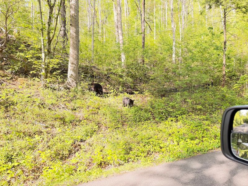
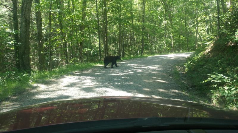
The paved circuit takes you past weathered log cabins, operating gristmills, and three historic churches dating back to the 1800s. Black bears often wander through the fields, especially during early morning and evening hours.
Many families pack picnics to enjoy at designated pull-offs while watching wildlife from a safe distance.
Driving the full loop typically requires two to four hours, depending on traffic and how often you stop to explore. Wednesdays and Saturdays before 10 a.m. are reserved for cyclists and pedestrians only during summer months.
This special car-free time offers a quieter experience for those who want to walk or bike the route.
The best strategy is arriving before 9 a.m. or after 3 p.m. to avoid midday crowds. Bring binoculars, a camera with a good zoom lens, and patience for the occasional traffic jam caused by bear sightings that make every moment worthwhile.
Roaring Fork Motor Nature Trail
A rushing creek soundtrack follows you along every twist of this narrow, one-way road that feels like stepping into a forgotten world. Massive hemlocks tower overhead while waterfalls tumble down rocky slopes just steps from your car window.
Roaring Fork Motor Nature Trail winds through one of the park’s most pristine old-growth forests, offering intimate encounters with nature that wider roads simply cannot match.
The 5.5-mile route begins just outside Gatlinburg and climbs through dense woodland past several preserved homesteads. You can park and walk short distances to explore the Noah Ogle cabin, Alfred Reagan’s Place, and several working mills.
Each stop reveals how mountain families lived and farmed these steep hollows over a century ago.
Spring transforms the roadside into a wildflower gallery, with trilliums and lady slippers blooming beneath the canopy. Summer brings cool shade perfect for escaping valley heat.
Fall delivers spectacular color displays that rival any place in the park, though you’ll share views with many other leaf-peepers.
The road closes during winter months, typically from late November through mid-March, when ice and fallen trees make passage dangerous. Plan for about an hour to drive without stops, but allow at least two for the full experience with short hikes.
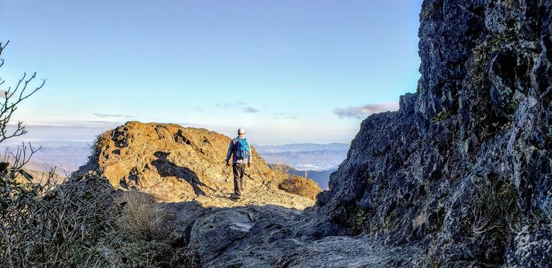
Alum Cave Trail
Cliffs soar overhead while the forest floor drops away into misty valleys far below—this popular trail packs drama into every mile. Wooden staircases cling to mountainsides, and metal cables offer handholds along exposed sections where courage meets spectacular reward.
Alum Cave Trail climbs 2,800 feet over five challenging miles to reach Mount LeConte’s summit, though most hikers turn around at the stunning bluff shelter halfway up.
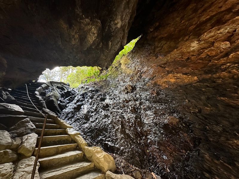
The namesake cave isn’t actually a cave at all but a massive concave bluff that shelters 80 feet of dry ground beneath its arch. Early settlers mined alum salts here during the Civil War.
Today, the cool, echoing space provides a perfect lunch spot with protection from rain or intense sun.
Beyond the bluff, the trail grows steeper and more rugged, requiring sturdy boots and strong legs. Inspiration Point offers breathtaking views without the full summit commitment.
Those who continue to the top find overnight lodge accommodations available by reservation only, since no roads reach this remote peak.
Start before 8 a.m. during peak season to secure parking at the trailhead, located along Newfound Gap Road about ten miles from Gatlinburg. Afternoon thunderstorms frequently develop in summer, making early starts not just convenient but safer for avoiding lightning on exposed ridges.
Charlies Bunion Trail
Wind whips across bare rock as you stand atop a knife-edge ridge with nothing but air and endless mountains in every direction. Getting here means hiking four miles along the famous Appalachian Trail, gaining 1,600 feet of elevation through spruce-fir forest that gives way to dramatic stone formations.
Charlies Bunion earned its quirky name in the 1920s when Charlie Conner, a park advocate, noticed the rocky outcrop resembled a foot bunion after a massive landslide exposed the cliff.
The trail begins at Newfound Gap parking area, right on the state line between Tennessee and North Carolina. Early sections wind through fragrant evergreens, their needles cushioning your footsteps.
Rhododendron tunnels create natural arches overhead before the landscape opens to reveal stunning vistas.
At the bunion itself, hikers carefully navigate narrow rock ledges to reach premier viewpoints. On clear days, you can see peaks stretching into three states.
Photographers love the layered ridges that fade from green to purple to blue as distance increases.
This challenging hike demands respect—sudden weather changes happen fast at this elevation, where temperatures run 10-15 degrees cooler than valleys below. Pack extra layers even on warm days, and watch for ice on shaded sections well into spring.
The round trip takes most people four to six hours depending on pace and photo stops.
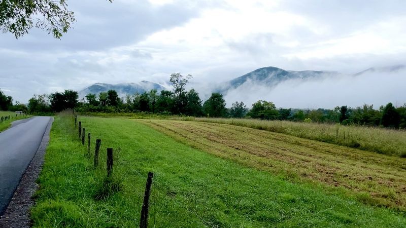
Newfound Gap Road
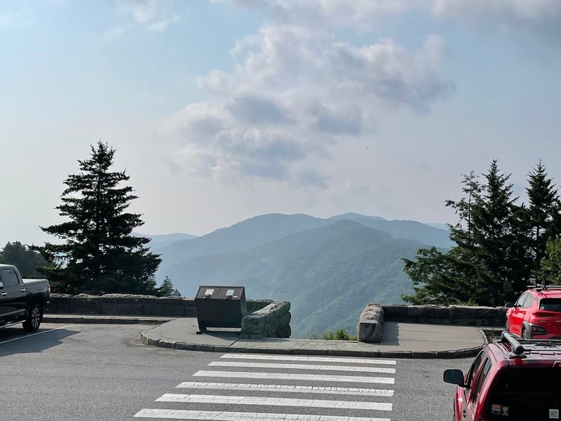
What if one road could show you everything that makes these mountains special? Newfound Gap Road accomplishes exactly that across 31 miles of continuous elevation change and ecosystem diversity.
Starting near sea level humidity in Cherokee, North Carolina, the highway climbs to 5,046 feet at Newfound Gap before descending into Gatlinburg, Tennessee—all while offering more than a dozen pull-offs for photos and trail access.
Unlike loop drives that return to your starting point, this transmountain route requires planning for a vehicle at each end or backtracking. Many visitors drive up one side for breakfast, explore the gap itself, then continue down the other side for lunch in a different state.
The journey typically takes 90 minutes without stops but deserves half a day for proper appreciation.
Each thousand feet of elevation brings noticeable changes in temperature and vegetation. Lower slopes feature deciduous hardwoods that explode with color in October.
Higher elevations host evergreen forests more typical of Canada than the southern Appalachians.
Morton Overlook on the Tennessee side offers perhaps the park’s most photographed sunrise view, where fog pools in valleys below while peaks glow orange and pink. Campbell Overlook provides equally stunning perspectives from the North Carolina approach.
Winter brings occasional closures for snow and ice, so check road conditions before planning cold-weather drives.
Rich Mountain Road
Dust kicks up behind your tires as you navigate one of the park’s few remaining unpaved routes, feeling every rock and rut beneath your wheels. Rich Mountain Road offers adventurers a completely different park experience—rougher, quieter, and far less traveled than its paved counterparts.
This one-way gravel track climbs from Cades Cove up and over Rich Mountain before descending to Townsend, covering eight miles of backcountry scenery that sedans handle surprisingly well when dry.
The dirt and gravel surface requires careful attention, especially after rain when slick spots and water bars challenge traction. Passing is impossible along most stretches, so traffic moves at a relaxed pace perfect for wildlife watching.
Wild turkeys strut across the road while squirrels chatter warnings from overhead branches.
Several pull-offs provide panoramic views back across Cades Cove, where the valley spreads like a green carpet between mountain walls. Spring brings mountain laurel and rhododendron blooms that transform the roadside into a natural garden.
Summer shade keeps temperatures pleasant even when valleys below swelter.
The road typically opens from April through November, closing during winter and periods of heavy rain. Check current conditions before attempting this route, as temporary closures happen without much notice.
Allow about an hour for the full journey, though you’ll want extra time for photographs and simply soaking in the solitude.
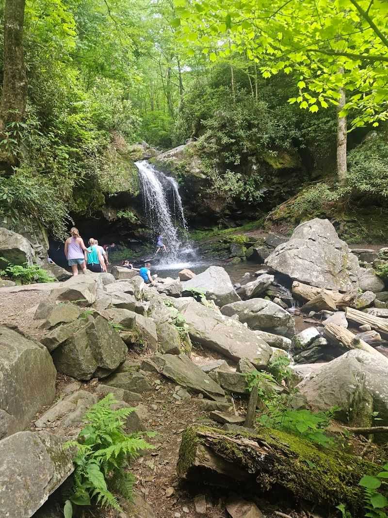
Grotto Falls Trail
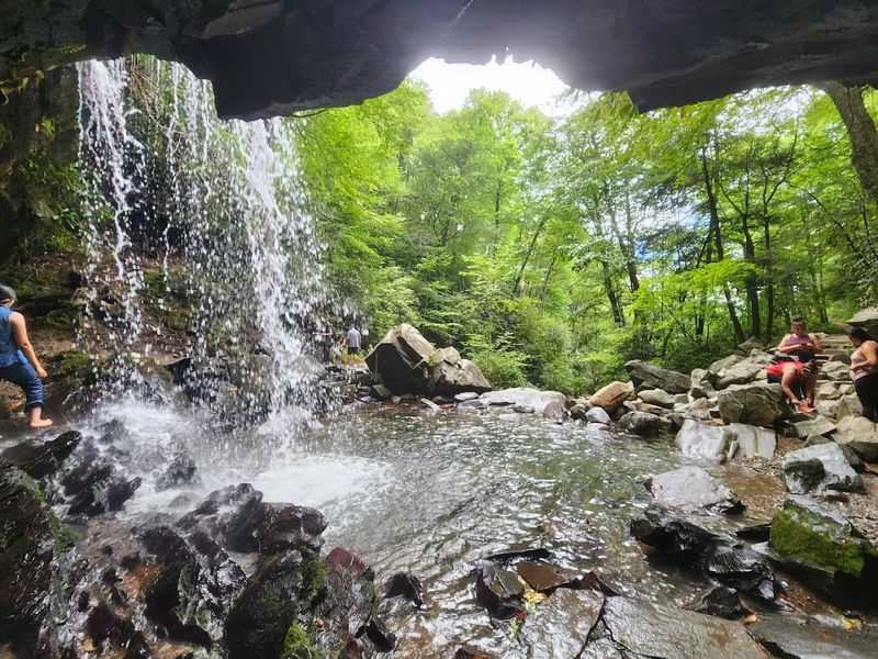
Few experiences match the thrill of walking behind a waterfall’s curtain while 25 feet of cascading water thunders just inches away. The path to Grotto Falls follows Trillium Gap Trail for 2.6 miles roundtrip through peaceful hardwood forest where salamanders cross the path after rains.
This moderately easy hike attracts families and first-time trail users who want memorable moments without extreme difficulty or danger.
The route gains about 500 feet in elevation as it follows a small creek upstream. Large boulders create natural seating areas perfect for snack breaks and stream watching.
During spring, countless wildflowers carpet the forest floor in yellows, whites, and purples that delight photographers and nature lovers equally.
When you finally reach the falls, an alcove behind the water allows you to walk through without getting soaked—though mist from the plunging stream will dampen clothes and cool overheated hikers. The constant spray nourishes moss and ferns that create a prehistoric atmosphere.
Many visitors report feeling like they’ve stepped into a fairy tale world back here.
Watch for llamas along this trail—yes, actual llamas! They carry supplies to LeConte Lodge several times weekly, passing hikers with barely a sideways glance.
The trailhead parking fills quickly on weekends, so arrive before 9 a.m. or prepare to park along the road and walk extra distance to reach the official start.
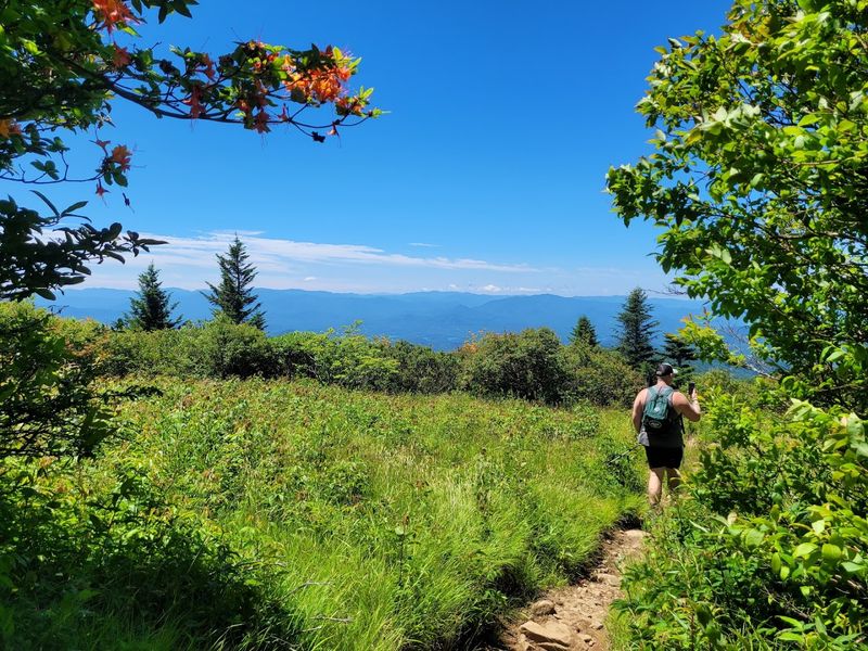
Andrews Bald Trail
Mountain balds remain one of Appalachia’s great mysteries—why do grassy meadows exist on certain peaks where forests should grow? Scientists debate theories while hikers simply enjoy the spectacular 360-degree views these natural clearings provide.
Andrews Bald sits along the park’s highest ridgeline, reached via a 3.6-mile roundtrip trail from Clingmans Dome parking area that descends 600 feet before climbing back up on the return.
The pathway winds through stunted spruce-fir forest damaged by invasive insects but slowly recovering. These high-elevation trees rarely grow taller than 20 feet even after decades, creating a miniature forest atmosphere.
Fraser firs fill the air with their distinctive evergreen scent, strongest after warm rain.
Breaking into the open bald feels like emerging from a tunnel into sunshine and space. Flame azaleas bloom in explosive orange bursts during June, while summer brings waist-high grasses that sway in constant breezes.
Butterflies drift across the meadow collecting nectar from wildflowers that bloom in waves through the growing season.
Despite starting from the park’s highest parking area, this trail actually goes downhill first—which means you’ll face an uphill finish when you’re already tired. Pack plenty of water and energy snacks for the return climb.
Morning hikes beat afternoon thunderstorms that commonly develop along this exposed ridge, especially in July and August when weather turns volatile quickly.
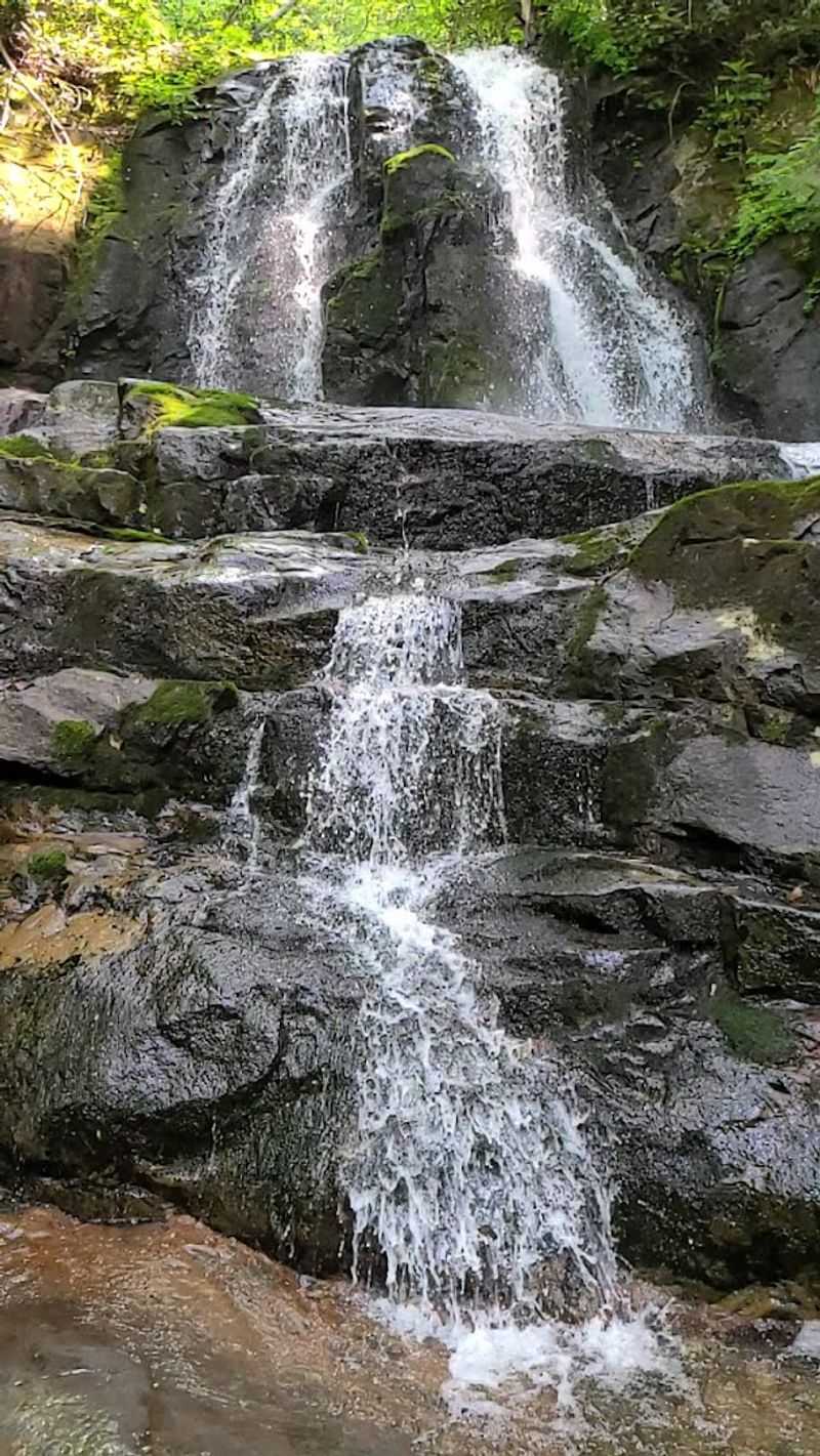
Cataract Falls Trail
Sometimes the shortest paths deliver the biggest rewards. Barely a mile roundtrip, this gentle walk leads to a charming series of small waterfalls that tumble over mossy rocks in tiers and slides.
Cataract Falls Trail begins at the end of Cove Mountain Road near Cosby, an area of the park that receives far fewer visitors than popular western sections despite offering equally beautiful scenery.
The well-maintained gravel path follows an old road grade, making it accessible for various fitness levels and even stroller-capable in dry conditions. Families with young children appreciate the short distance and rewarding destination.
Interpretive signs along the way explain forest ecology and point out interesting plant species.
At the falls, wooden bridges cross the stream multiple times, offering different angles for photographs. Water volume varies dramatically with rainfall—spring runoff creates impressive torrents while late summer reduces flow to gentle cascades.
Both seasons have unique charm, with autumn adding brilliant leaf color that reflects in the pools.
The parking area holds maybe a dozen vehicles, and this relative obscurity means peaceful experiences even on busy holiday weekends when other trails feel like highways. Nearby Cosby Campground provides base camp for exploring this quieter corner of the park.
The trailhead sits at about 2,400 feet elevation, staying comfortable year-round except during occasional winter ice storms that make the area impassable until spring thaw arrives.
Laurel Falls Trail
An 80-foot waterfall tumbling in two distinct drops rewards everyone who walks this paved path, regardless of hiking experience or physical limitations. Laurel Falls Trail ranks among the park’s most accessible adventures, with a hard surface that accommodates wheelchairs for the first half-mile and remains easier than most mountain paths throughout its 2.6-mile roundtrip length.
This popularity comes with crowds—expect company, especially during peak summer weekends and fall color season.
The trail climbs about 300 feet gradually through mountain laurel thickets that explode with white and pink blooms in late April and May. These same shrubs create natural tunnels of green during summer, offering shade appreciated on hot afternoons.
Several spots along the way provide valley views between the vegetation.
At the falls themselves, an observation platform allows close viewing of both upper and lower cascades. Mist from the plunging water creates rainbows on sunny days and keeps surrounding rocks perpetually wet and slippery.
Warning signs remind visitors to stay on designated areas rather than climbing on the slick stones, where several people have been injured over the years.
Parking fills completely by mid-morning during busy periods, forcing later arrivals to wait for spaces or park dangerously along the highway. Arrive before 8 a.m. or after 5 p.m. for easier access.
Winter transforms the falls into stunning ice formations on cold days, though the paved trail can become treacherous when frozen.