
Craving a mountain escape without losing a day on the road?
The Sky Island Scenic National Byway climbs from cactus desert to pine forest in just 24 twisting miles, packing in climate zones, trailheads, and overlook stops that feel wildly different at every turn. You will watch saguaros fade into granite spires and cool breezes as the pavement switchbacks toward Mount Lemmon.
Buckle up, because this short drive delivers big drama and even bigger views.
Overview of the Sky Island Scenic National Byway

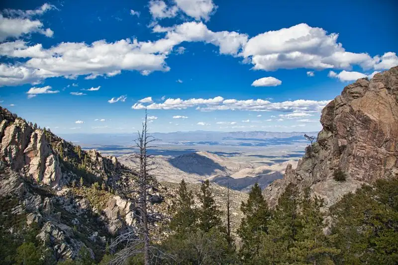
The Sky Island Scenic National Byway is a 24-mile ascent along the Catalina Highway that climbs from Tucson’s Sonoran Desert to the cool forests near Mount Lemmon. In less than an hour, you can traverse ecological zones that otherwise require a multi-state drive. The transformation is immediate, dramatic, and packed with places to pull over.
Expect a well-maintained road with steady switchbacks, guardrails in key sections, and frequent signed viewpoints. Cell service drops in places, so download maps. The drive is open year-round, though winter storms can close upper segments temporarily.
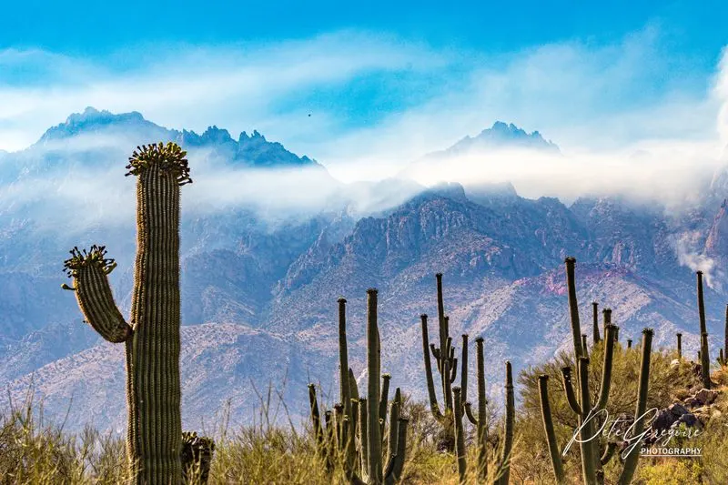
You will start among saguaros and cholla, then pass through oak woodland, juniper, and eventually ponderosa and mixed conifer. Every few miles brings new rock textures, temperatures, and scents. Keep an eye out for changing speed limits and cyclists sharing the climb.
There are fee stations for the Coronado National Forest recreation pass when stopping at developed sites. Carry water even in cooler months. If you time the drive for golden hour, the granite takes on a warm glow and shadows carve depth into the canyon walls, turning a simple road trip into a memory.
Starting point: Lower Sonoran Desert segment

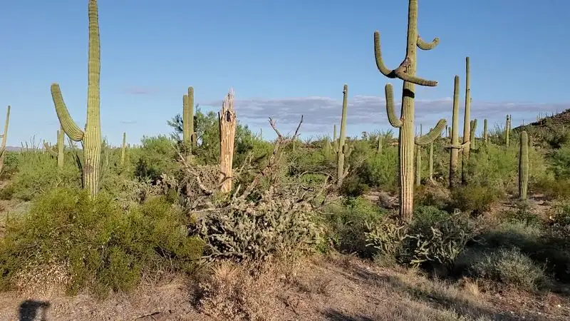
The drive begins just northeast of Tucson where saguaros stand like sentinels over sandy washes. Early in the morning, the desert smells sweet after overnight dew, and curve signs lead you into the foothills. Temperatures here can soar, so start with a full water bottle and sun protection.
Pullouts reveal postcard views of the Tucson basin and the Santa Ritas far south. You will notice ocotillo wands, prickly pear, and barrel cactus thriving on rocky slopes. Roadside interpretive panels highlight how these plants store water and survive long droughts.
Traffic includes commuters, cyclists, and hikers heading to trailheads, so pass carefully and keep speeds moderate. Rattlesnakes sometimes warm on shoulders in spring. Use designated turnouts for photos to keep the flow safe.
This lower stretch sets the stage for the elevation story you are about to live. Within minutes, mesquite and palo verde yield to higher, cooler species. The soundscape shifts too, from cicadas and cactus wrens to ravens riding thermals. You will feel anticipation building as the grade steepens and the mountain’s granite ramparts rise, promising shade, breezes, and a new palette of Arizona.
Geology of the Catalina Highway corridor

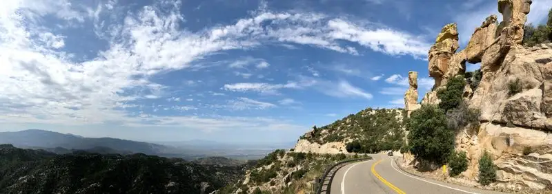
The Santa Catalina Mountains are a geologic showcase carved from hard Precambrian granite and gneiss, lifted and fractured by regional tectonics. As you climb, the road threads through canyons where boulders stack like toppled dice. Erosion sculpts hoodoos, spires, and massive fins that catch sunrise and sunset.
Look closely at exfoliation domes where sheets of granite peel like onion layers. Vertical joints create columns that seem improbably balanced. The stone’s mica sparkles in bright light, and lichens paint surfaces with mustard and sage tones.
Pullouts often sit near faulted outcrops with interpretive signs that explain the mountain’s metamorphic history. You will also notice talus slopes below cliffs, a reminder that freeze-thaw cycles continue shaping this landscape. Each bend reveals a new angle on the same ancient rock.
Bring a small hand lens if you are curious about minerals. Even without tools, the textures reward slow looking. Photograph safely from designated areas. It is easy to understand why climbers flock here, but for drivers, the roadside geology offers a masterclass in deep time while keeping the adventure inside your car.
Ecological sky island transitions

Sky islands are mountain ranges isolated by surrounding low desert, creating biological stepping stones. On this 24-mile climb, you cross several life zones usually separated by hundreds of miles north to south. You can literally feel the temperature drop as vegetation shifts around you.
Saguaros give way to oak and mesquite, then pinyon and juniper, and finally ponderosa pine. Closer to the top, Douglas-fir and aspen appear in cool drainages. Birdsong changes too, from cactus wrens and Gila woodpeckers to chickadees and warblers.
This gradient makes the byway a dream for naturalists. After summer monsoon rains, wildflowers bloom in stair-steps, with different species peaking at different elevations. Fall color appears in canyon maple and aspen patches in October, a surprise in southern Arizona.
Respect closures that protect sensitive habitats. Stay on established paths when you stop to explore. Even short strolls reveal mushrooms under pine duff, butterflies puddling at seeps, and scent trails of resin and crushed needles. The drive is not just scenery. It is a living laboratory showing how altitude shapes life, all within a single afternoon.
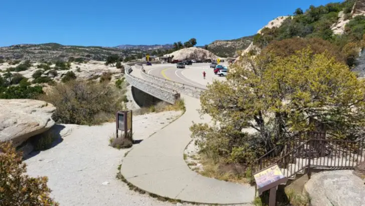
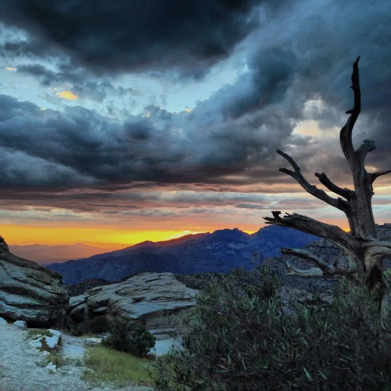
Iconic stop: Windy Point Vista

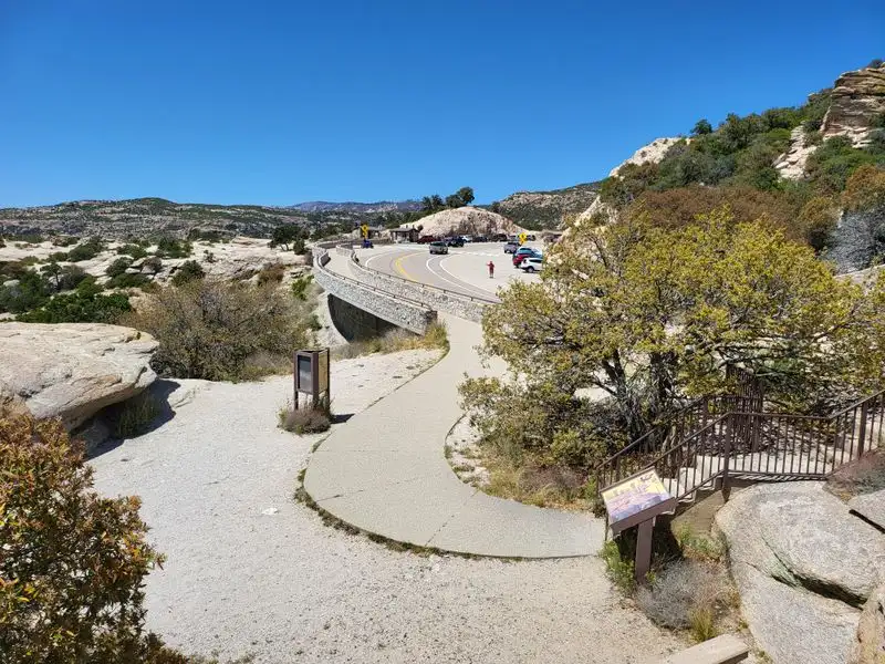
Windy Point Vista, at 930 Catalina Hwy, is the showstopper overlook and a must-stop day or night. Stone terraces perch on a precipice with 180-degree views across the Tucson basin and serrated ridgelines. The spot is open 24 hours, so it is perfect for sunrise, sunset, and stargazing.
Expect strong gusts that live up to the name. Bring a light layer even in summer. Photographers love the way long shadows carve detail into the hoodoos below, and headlights tracing the highway make great night compositions.
There is ample parking, but weekends can be busy. Be patient and use marked spaces. Railings provide safety, yet footing still matters near edges. Interpretive signs explain geology and ecology, adding depth to the view.
After your stop, grab a snack from your cooler and linger. You will hear ravens riding thermals and sometimes spot climbers on nearby spires. The overlook’s coordinates are 32.3683864, -110.7166607, and it anchors many itineraries on the byway. Do not rush. This vista captures why the drive ranks among the Southwest’s most memorable road trips.
Cycling the climb

Cyclists consider the Catalina Highway one of Arizona’s classic climbs. The grade is steady, scenery shifts constantly, and cool air near the top rewards the effort. Start early to avoid traffic and heat, and use bright lights for tunnels and shade patches.
Shoulders vary in width, so ride predictably and hold a line. Drivers are generally courteous, but holiday weekends can be hectic. Water refills are limited, so plan stops and carry enough for the lower desert segment.
Windy Point is a great morale booster and regroup spot. From there, the grade continues, but the views only get better. Descending requires caution. Corners tighten quickly, and sand or pine needles may accumulate after storms.
If you want a shorter day, shuttle to mid-mountain and ride a segment. Always bring a jacket for the descent. Temperatures can be 20 to 30 degrees cooler near the summit. The combination of elevation gain and scenery makes this ride unforgettable, whether you chase personal records or simply spin toward pine scented air and sweeping horizons.
Hiking pullouts and short trails

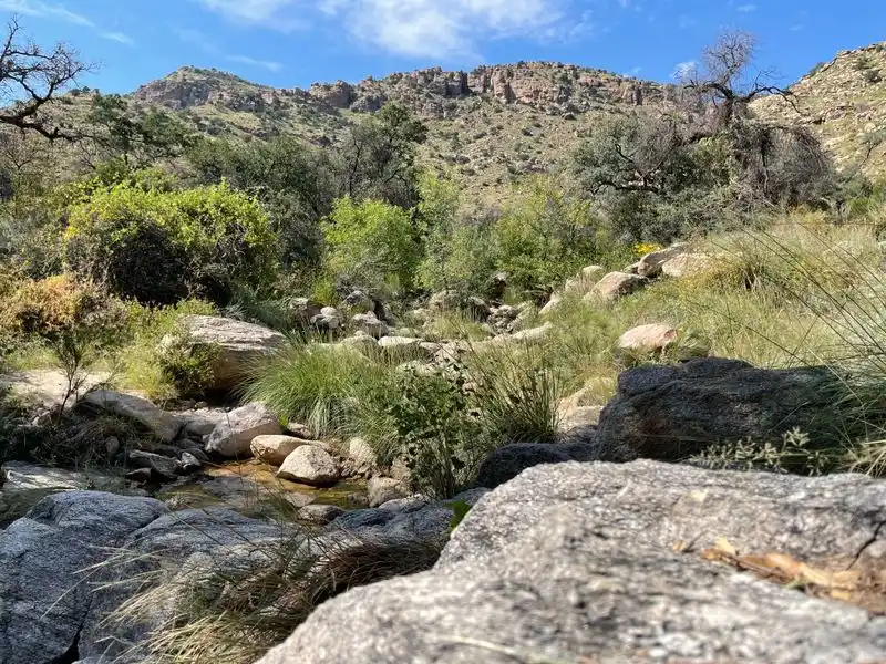
Even if you are focused on the drive, short hikes add texture to the day. Many pullouts access quick paths into oak and pine, letting you stretch legs and breathe cooler air. Always lock your car and carry water, even for brief strolls.
Popular stops include Molino Basin and Bear Canyon for lower elevation walks. Mid-mountain, look for trails near Windy Point that meander among spires and ledges. At higher elevations, Meadow and Aspen Loop near the top offer gentle forest circuits.
Stay on marked routes to protect fragile soils and plants. Afternoon storms in summer can bring lightning, so plan to be below ridgelines early. Trail surfaces range from sandy to rocky, with occasional steps or roots.
Wildlife sightings are a bonus. You might spot deer slipping through shadows or hear Abert’s squirrels chatter from the canopy. Even 20 minutes off the pavement can reset your mood and sharpen your senses. These micro adventures pair perfectly with scenic pullovers, giving the byway a choose-your-own-pace rhythm.
Rock climbing and hoodoo exploring

The granite spires along the byway are a magnet for climbers. Crags near Windy Point, Goosehead, and Ridgeline offer routes from moderate to advanced. If you are new to the area, consider hiring a local guide for safe anchor building and route finding.
Scramblers can explore hoodoos from designated areas without roping up. Watch for loose rock and respect closures that protect raptor nests. Sticky rubber approach shoes help on slabby sections, and helmets are smart for everyone.
Afternoons can be windy, which keeps temperatures pleasant but complicates rope management. Start early or chase shade to maintain good grip. Monsoon season brings sudden storms, so always track radar and be ready to retreat.
Even from the parking pullouts, the sculpted formations are mesmerizing. Photograph textures and lichens up close, then step back for sweeping compositions. The combination of stone architecture and sky makes this one of Arizona’s most distinctive climbing corridors, with roadside access that still feels wild and untamed.
Seasonal conditions and weather strategy

Weather shifts quickly on this mountain. Summer brings afternoon monsoon storms with lightning, heavy rain, and brief hail. Mornings are typically clear, so plan hikes and viewpoints early, then enjoy sheltered stops if clouds build.
Winter can dust the upper highway with snow, and temporary closures are common. Check Coronado National Forest updates before driving. Chains are rarely needed, but traction can be an issue on shaded curves.
Spring and fall deliver ideal conditions with crisp air and long views. Layer clothing because the summit can be 20 degrees cooler than Tucson. Sunscreen matters year-round, as UV increases with elevation.
Carry water, snacks, and a small emergency kit. Download offline maps in case service drops. If thunder rolls, avoid exposed overlooks and high ridgelines. Flexibility is your friend. With a little planning, you can weave around weather and still enjoy the byway’s best moments safely.
Picnic spots and viewpoints beyond Windy Point

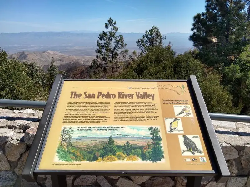
While Windy Point steals the show, many quieter overlooks wait around the next bends. San Pedro Vista frames distant river valleys. Further up, Hoodoo Vista and Geology Vista offer textbook views with fewer crowds and excellent interpretive panels.
Pack a picnic and use stone tables tucked under pines at developed sites. Keep your cooler secure to deter curious ravens and squirrels. Always pack out every crumb to protect wildlife behavior.
These stops are perfect for midday breaks when light is harsh for photos. Rest, hydrate, and let the mountain breezes carry off the heat. The sound of wind in needles has a calming rhythm that resets road trip energy.
Golden hour can be spectacular at the lesser-known pullouts. You will have room to set up a tripod and watch shadow lines stroll across ridges. Rotate through several viewpoints during your visit. Each one has a distinct angle on the Catalina story, making the short drive feel vast.
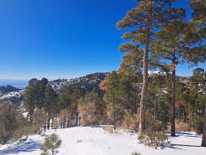
Mount Lemmon recreation area near the top

Nearing the top, the road enters cool pine forest and opens into the Mount Lemmon recreation area. Here, you will find picnic sites, short trails, and the kind of crisp air that smells like camp memories. In summer, this zone becomes Tucson’s natural air conditioner.
Trails like Meadow Loop offer easy walking with big rewards. Birders appreciate mixed conifer habitat where warblers and nuthatches flit between branches. Shade is generous, and afternoon clouds often paint dramatic skies.
Facilities vary, so bring essentials. Some sites require a recreation pass and have vault toilets. The setting invites a slow pace. Enjoy lunch, listen for woodpeckers, and savor the quiet that contrasts with the bustling city below.
This high country stretches the definition of Arizona in the best way. If time allows, linger until the light softens and scent deepens. The juxtaposition of desert start and alpine finish is the secret sauce of this byway. You will leave refreshed, cooler, and already plotting a return.
Night skies and stargazing along the byway

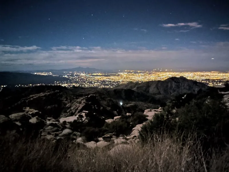
After sunset, the byway shifts into a stargazer’s haven. Higher elevations rise above a chunk of the city glow, revealing constellations and the Milky Way on moonless nights. Windy Point and nearby pullouts provide safe, open horizons.
Bring a red-light headlamp to protect night vision. Tripods help with long exposures, and a wide lens captures the granite foregrounds that make photos pop. Dress warmer than you think. Night air up high can be surprisingly chilly.
Summer Milky Way season pairs beautifully with monsoon cloud breaks. Winter brings crisp transparency and bright Orion. Watch for meteors during annual showers like Perseids and Geminids.
Be mindful of other visitors enjoying the quiet. Keep voices low, lights pointed down, and vehicles parked fully in marked spaces. If you have time, let your eyes adapt for 20 minutes. You will notice more stars than you imagined, capping a perfect day on Arizona’s most compact epic drive.
Logistics, permits, and safety essentials

Before rolling out, check Coronado National Forest pages for current conditions and any closures. A recreation day pass is required to use developed sites and picnic areas along the byway, available online and at vending machines. Keep it visible on your dashboard.
Fuel up in Tucson because there are no gas stations on the climb. Restrooms are at select pullouts, not every stop. Pack more water than you think you need, plus salty snacks to handle elevation and dry air.
Safety starts with pacing yourself. Use turnouts to let faster traffic pass and to enjoy views without pressure. Weather can flip quickly, so stash a light jacket and check radar during monsoon season.
Cell coverage is inconsistent. Download offline maps and share your plan with a friend. If you bring pets, keep them leashed at developed sites and never leave them in vehicles. With a little preparation, this 24-mile drive feels seamless, letting you focus on the changing scenery and unforgettable moments.