Travelers increasingly notice that America’s prosperity and its housing stress share the same sidewalks. In many cities, visible encampments, RV clusters, and outreach teams have become part of the urban landscape, shifting block by block and month by month. Understanding where and why visibility appears can help visitors navigate with empathy and context. This guide highlights patterns, places, and policies shaping what you’ll see—and why it changes so often.
Los Angeles — Skid Row, freeway underpasses, and the city edge
Visitors often first encounter visible homelessness in and around Skid Row, pockets of Downtown, and freeway underpasses stretching toward the industrial edges. Encampments may appear along riverbeds, warehouse corridors, and near service hubs, though patterns shift with outreach and encampment-clearance campaigns. Neighborhoods like Echo Park, Venice, and Hollywood have seen fluctuating visibility following targeted efforts and temporary shelter expansions. One month a corridor looks crowded; the next, dispersed. The tension between urgent humanitarian need and public-space management is palpable. Travelers may notice hygiene stations, storage areas, and outreach teams working to connect people with shelter, medical care, and housing resources.
San Francisco — downtown corridors, the Tenderloin, and changing street policies
In San Francisco, visitors commonly see homelessness in downtown corridors, the Tenderloin, SoMa blocks, and near freeway ramps or small parks. Visibility can swing week to week due to encampment clearings, storage rules, and service offers. Cleanup crews and outreach teams shift footprints, moving tents and belongings while connecting some people to shelter. On one visit, a block may be lined with carts and tarps; on the next, it’s cleared, with activity relocated elsewhere. Side streets near Market and civic buildings often tell the city’s policy story in real time. Travelers should expect episodic changes shaped by both services and enforcement.
Seattle — downtown and certain transit corridors
Seattle’s visibility often centers downtown, in parts of Pioneer Square, and along certain transit corridors with bus stops and light-rail stations. Tents, RVs, or makeshift shelters may appear near greenbelts or underpasses, though municipal efforts have reduced counts in some locations. Weather influences where people stay: covered areas and awnings grow busier during persistent rain. Outreach teams and hotel-to-shelter placements continue, so a visitor’s impression depends on timing and route. Waterfront and stadium districts can look different on event days. Neighborhoods north and south of downtown present varied patterns, reflecting local service access, enforcement priorities, and evolving public-space rules.
Portland (Oregon) — inner neighborhoods and riverfront areas
In Portland, long-running encampments have appeared along parts of the riverfront, near bridge entrances, and in inner neighborhoods. Visitors may notice tents, signage, and community responses such as volunteer groups distributing supplies. Downtown blocks present a patchwork of cleared areas and re-formed clusters, influenced by city policies and service availability. Residential corridors sometimes host smaller, more dispersed sites. Cycling the waterfront or crossing certain bridges often reveals the contrasts: scenic recreation next to visible poverty. Outreach teams, sanitation services, and neighborhood advocates shape daily conditions. Expect differences block to block, as tents shift with cleanups, weather, and access to restrooms or shelters.
New York City — shelters, subway corridors, and visible street presence
New York’s vast shelter network coexists with visible street homelessness, especially around busy subway stations, park perimeters, and commercial corridors. Visitors often notice people near station entrances, under scaffolding, or in transit hubs where warmth and foot traffic are reliable. Seasonal swings matter: winter shelters and summer street life change patterns, as do recent migration trends. Outreach teams offer placement and medical care, while enforcement influences congregating spots. In Midtown, Lower Manhattan, and parts of Brooklyn and the Bronx, the streetscape can shift daily. Travelers might see storage carts, blankets, or makeshift bedding near vents, plazas, or underpasses.
San Diego — waterfronts, sidewalks near transit, and recent clearance actions
San Diego’s visibility often concentrates near downtown waterfronts, transit-adjacent sidewalks, and canyon-adjacent neighborhoods. Encampments have shifted with state and city clearance initiatives, creating contrasts between polished tourist areas and nearby blocks where outreach teams operate. Visitors walking from the Embarcadero into East Village may notice tents, storage, and cleanup activity. Sunny weather and mild nights influence outdoor living, while shelters and safe-sleep sites guide movement. The result is a dynamic map: some stretches suddenly cleared, others re-forming. Expect to see service vans, water stations, and signage pointing to assistance programs as the city balances hospitality with humanitarian response.
Las Vegas — strips and outskirts, RVs, and tent clusters
Las Vegas contrasts glittering resorts with visible homelessness in nearby blocks off the Strip and along arterial roads. Visitors may encounter tent clusters, people sheltering under overpasses, and RV living in the valley’s outskirts. Extreme heat and limited shade push people toward viaducts, service centers, and cooling sites in summer. Outreach teams connect individuals to shelters and water, but capacity and distance matter. Daytime foot traffic near casino corridors can mask adjacent side streets where visibility is concentrated. As enforcement ebbs and flows, clusters shift between lots, washes, and underpasses, making impressions highly dependent on time of day and route.
Phoenix — downtown and shaded corridors
Phoenix’s arid climate concentrates visibility where shade, water, transit, and services converge—downtown blocks, underpasses, and public plazas. Visitors might notice clusters near shelter providers, light-rail stations, and courthouse areas. In extreme heat, outreach teams direct people to cooling centers and hydration stations, influencing day-to-day patterns. Encampment clearances and fencing alter specific streets, while RVs and tent sites appear along wider arterials. Nighttime brings different dynamics as people seek airflow and safety in groups. The city’s rapid growth and rents heighten pressure on limited affordable housing, shaping what travelers observe during walks between cultural venues, stadium districts, and government buildings.
Denver — transit lines, parks, and evolving downtown patterns
In Denver, encampments have formed near transit corridors, river greenways, and parks, with visibility shifting as the city redevelops and manages public spaces. Downtown blocks can change monthly due to outreach, shelter availability, and targeted cleanups. Visitors riding light rail or walking to Union Station may notice tents near rights-of-way, river trails, and adjacent streets. Seasonal events and winter weather move people toward sheltered areas. Service providers, sanctioned sites, and hotel conversions influence flows. Expect to see a mix of cleared zones and re-formations, as the region balances tourism, commuter traffic, and an expanding population in need of affordable housing.
Austin — downtown, I-35 corridor, and tent sites
Austin’s rapid growth and rising rents intersect with visible homelessness near downtown, the I-35 corridor, and park edges. Visitors may see tents under overpasses, near creeks, and by service centers, with patterns shaped by city rules and nonprofit outreach. Cleanup actions and sanctioned camping debates have shifted where people stay. On a festival weekend, crowds may obscure nearby encampments; afterward, visibility returns. East-west divides across the interstate matter, as do shaded spots during hot months. Expect to see water distribution, mobile clinics, and storage solutions alongside enforcement zones, producing a constantly changing streetscape for people walking between venues and neighborhoods.
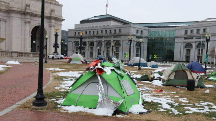
Washington, D.C. — certain neighborhoods, transit stops, and service hubs
In Washington, D.C., visibility often clusters near some transit stops, park perimeters, and service hubs where food and case management are accessible. Visitors walking between museums, offices, and residential neighborhoods may notice tents under viaducts or near freeway ramps. Federal, city, and nonprofit systems overlap, shaping shelter access and cleanup schedules. Outreach teams and encampment protocols can temporarily reduce tents in high-traffic areas, while activity shifts to adjacent blocks. Seasonal swings matter: extreme heat and cold weather drives people toward designated centers. The result is a mosaic—highly maintained federal spaces bordering streets where homelessness remains strikingly present.