Arizona is one of those places that makes you stop and stare, whether you’re standing on the edge of a massive canyon or sliding down a natural rock waterfall.
From red rock formations to slot canyons, the state is packed with outdoor adventures that suit every type of explorer.
In 2026, Arizona’s trails, parks, and wild landscapes are calling your name.
Whether you’re planning a family trip or a solo escape, these eleven experiences will leave you with memories that stick around long after the trip is over.
Grand Canyon National Park – Grand Canyon
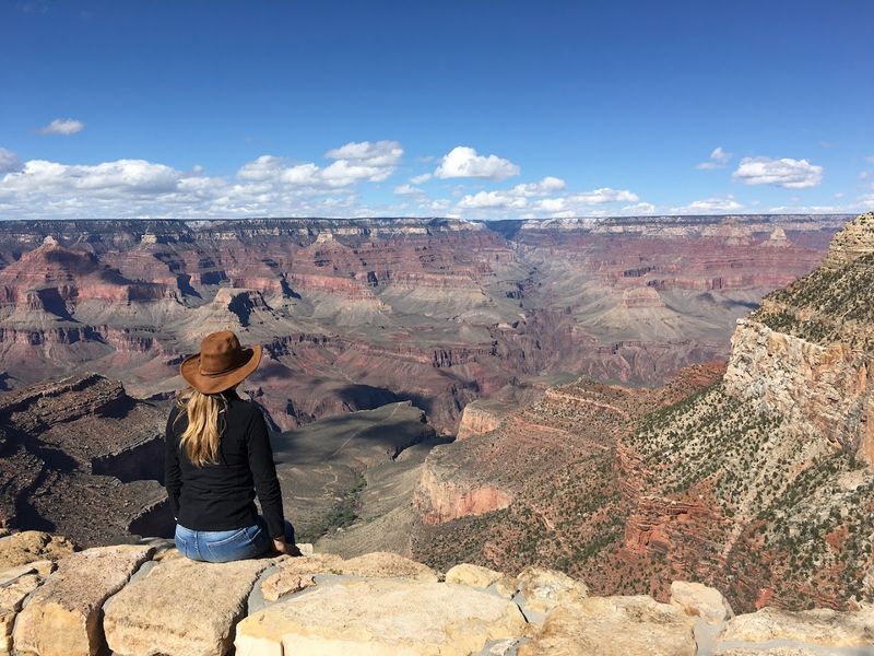
Standing at the rim of the Grand Canyon for the first time is something your brain almost refuses to believe. The canyon stretches 277 miles long, up to 18 miles wide, and over a mile deep — numbers that don’t fully make sense until you’re actually looking at it.
Few places on Earth match this kind of raw, overwhelming scale.
Hiking trails like Bright Angel and South Kaibab take you down into the canyon, where the colors shift from burnt orange to deep purple the farther you descend. Rim Trail is a great option for families or anyone who prefers a flatter walk with equally stunning views.
Early morning hikes reward you with cool temperatures and soft golden light that makes the canyon walls glow.
River rafting through the canyon is another bucket-list option, especially for thrill-seekers who want to experience the Colorado River up close. Multi-day rafting trips are available and give you a completely different perspective of the canyon walls towering above you.
Book permits and tours well in advance, as spots fill up fast, especially during peak seasons in spring and fall.
Red Rock State Park – Sedona
Sedona has a way of making every hiker feel like they’ve stumbled into a painting. Red Rock State Park sits at the heart of this iconic landscape, offering trails that wind through towering sandstone formations in shades of rust, copper, and crimson.
The scenery here is genuinely hard to put into words.
Cathedral Rock and Bell Rock are two of the most photographed landmarks in all of Arizona, and both are accessible from well-marked trails inside the park. The reflection of Cathedral Rock in Oak Creek is a classic shot that photographers chase during golden hour.
Even casual walkers can enjoy the views since several trails are relatively short and manageable for most fitness levels.
Wildlife sightings are common here — keep an eye out for mule deer, roadrunners, and various hawk species soaring above the cliffs. Bring plenty of water because the desert sun can be intense even in cooler months.
Guided nature walks are available if you want to learn more about the geology and plants that make this part of Arizona so distinctive. Arrive early on weekends to snag a parking spot before the crowds roll in.
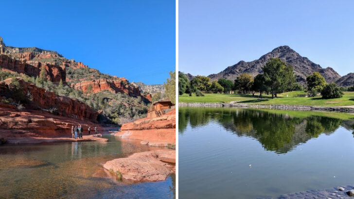
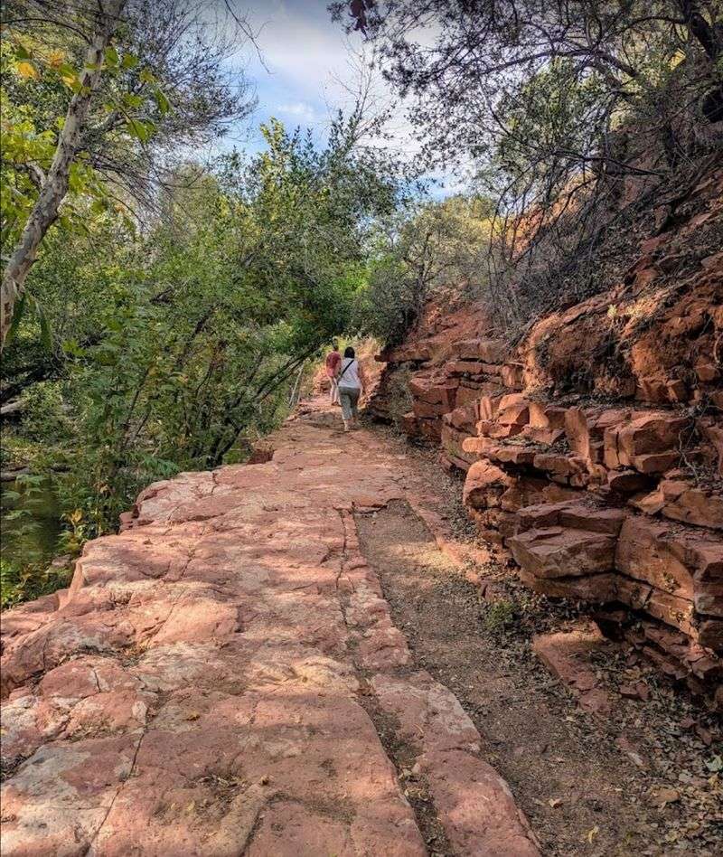
Slide Rock State Park – Sedona
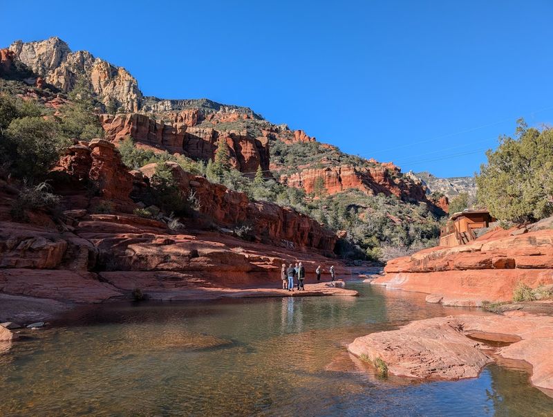
Picture a natural waterpark carved out of red sandstone — that’s exactly what Slide Rock State Park delivers. Located in the lush Oak Creek Canyon just north of Sedona, this park was originally a working apple orchard in the early 1900s before becoming one of Arizona’s most beloved swimming destinations.
The orchard’s heritage is still visible in the historic buildings and apple trees scattered throughout the grounds.
The main attraction is the natural rock slide, a smooth stretch of slippery sandstone that sends swimmers gliding into a cool, refreshing pool below. On a scorching Arizona summer day, there’s nothing quite like it.
Water shoes are highly recommended since the rocks can be rough on bare feet, and the current moves faster than it looks from the banks.
Beyond the slides, the park has shaded hiking trails that follow Oak Creek deeper into the canyon, offering a quieter escape from the splash zone. The scenery is stunning year-round, with fall bringing golden leaves that contrast beautifully against the red rock walls.
Timed entry reservations are required during peak summer months, so plan ahead and book your slot before it fills up.
Petrified Forest National Park – Holbrook
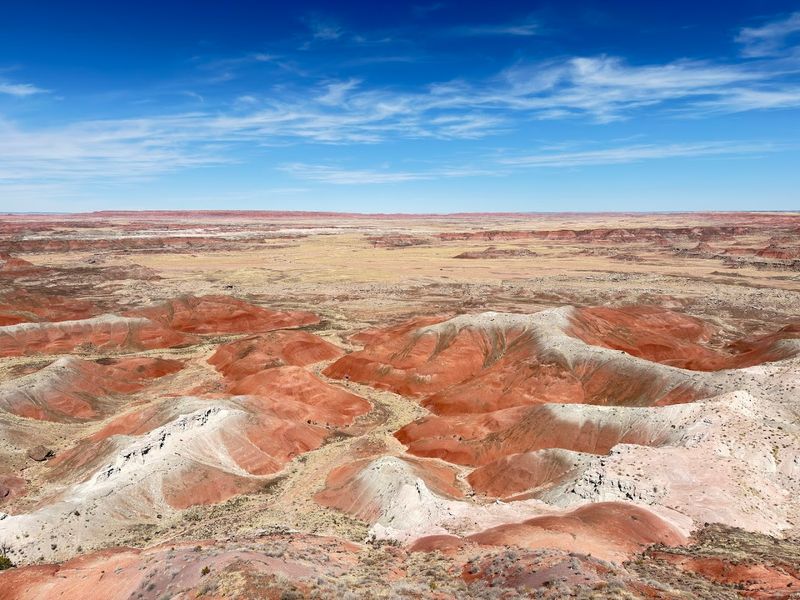
Roughly 225 million years ago, massive trees fell in what is now northeastern Arizona, got buried under volcanic ash, and slowly turned to stone. Today, those fossilized logs lie scattered across the desert floor at Petrified Forest National Park, their interiors sparkling with purple amethyst and golden quartz crystals.
It’s one of the most visually surreal landscapes in the entire country.
The park is split into two sections — the Painted Desert in the north and the petrified wood fields in the south. A 28-mile scenic drive connects both areas and includes pullouts with interpretive signs explaining the geology and history.
Hiking trails like the Giant Logs Loop take you right up close to some of the largest fossilized specimens, some measuring over five feet in diameter.
Wildlife is surprisingly abundant here, with pronghorn antelope, badgers, and short-horned lizards roaming the open terrain. Stargazing after dark is exceptional thanks to minimal light pollution in the surrounding area.
One important rule: removing even a small piece of petrified wood is illegal and comes with a serious fine.
Visitors have actually returned stolen pieces by mail over the years, with guilt-filled letters attached — a quirky tradition the park calls its “conscience pile.”
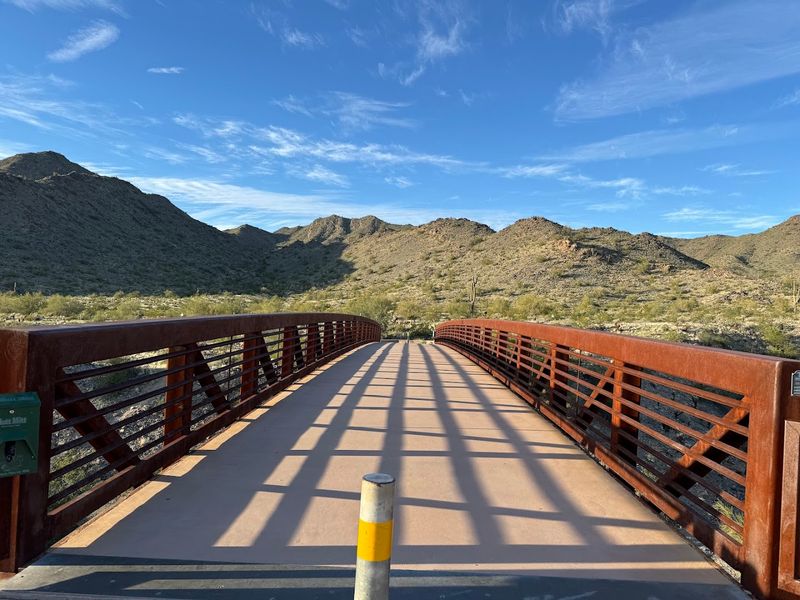
McDowell Sonoran Preserve – Scottsdale
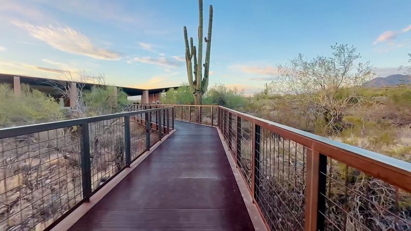
Right on the edge of Scottsdale, the McDowell Sonoran Preserve feels like a world away from the city’s resorts and shopping districts. Covering over 30,000 acres, it’s one of the largest urban preserves in the entire United States, and it offers more than 180 miles of well-maintained trails for hikers, mountain bikers, and horseback riders.
The sheer variety of routes means you can visit dozens of times and never repeat the same path.
Saguaro cacti tower along nearly every trail, their thick arms stretching skyward in that iconic Arizona silhouette. The McDowell Mountains provide a dramatic backdrop, and summit trails like the Tom’s Thumb route reward the effort with sweeping 360-degree views of the Sonoran Desert and the Phoenix metro area far below.
Spring wildflower season, usually peaking in March and April, turns the desert floor into a colorful carpet of poppies and lupine.
Sunrise and sunset hikes are especially popular here since the lighting turns the rocky terrain into shades of amber and rose. Trailhead parking fills quickly on weekends, so arriving before 7 a.m. is a smart move.
Carry at least two liters of water per person regardless of the season, because the desert heat can sneak up on you fast.
Tonto Natural Bridge State Park – Payson
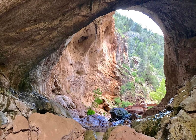
Tonto Natural Bridge holds a record that surprises most visitors: it’s considered the largest natural travertine bridge in the world. Stretching 183 feet high and spanning 150 feet across, the formation was created over thousands of years as mineral-rich spring water deposited calcium carbonate layer by layer.
The result is a massive stone arch that looks almost too grand to be real.
Four short but steep trails lead down into the canyon and to the base of the bridge, where you can wade through the cool creek water and look straight up at the arch overhead. The Gowan Trail is the most popular and offers the best views, while the Pine Creek Trail takes you right under the bridge for an unforgettable perspective.
The canyon is shaded and noticeably cooler than the surrounding desert, making it a refreshing midday stop in summer.
Photographers go wild for this spot, especially in the morning when soft light filters through the canyon walls. The park is located about 90 miles north of Phoenix near the town of Payson, making it a perfect day trip destination.
Weekday visits are quieter and allow more time to explore without competing for trail space. Bring water shoes for the creek crossings.
Airport Mesa – Sedona
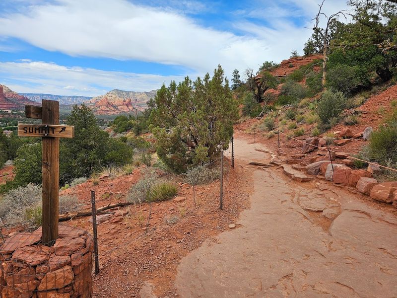
Not every great view in Sedona requires a full day of hiking. Airport Mesa sits just above the town and delivers one of the most jaw-dropping 360-degree panoramas in the entire red rock region — and the main loop trail is only about 3.5 miles with modest elevation gain.
It’s the kind of hike that makes you feel like you earned a spectacular reward without completely destroying your legs.
Sunrise visits are absolutely worth the early alarm. As the sun clears the eastern horizon, it sets the red rocks on fire with shades of orange, pink, and gold that shift by the minute.
Sunset is equally dramatic, drawing crowds who gather at the top with cameras ready and snacks in hand. Weekday visits significantly cut down on the number of people you’ll share the summit with.
The mesa is also considered one of Sedona’s famous “energy vortex” sites, a concept rooted in local spiritual traditions that draws visitors looking for a meditative outdoor experience. Whether or not you buy into the vortex lore, the peaceful atmosphere and stunning scenery make it worth the visit.
Parking near the trailhead can be competitive, so arrive at least 30 minutes before sunrise or sunset to secure a spot.
Skyline Regional Park – Buckeye
Most people driving through Buckeye on their way somewhere else have no idea they’re passing one of the Phoenix metro area’s most underrated outdoor gems. Skyline Regional Park covers over 16,000 acres of rugged Sonoran Desert terrain and offers more than 35 miles of multi-use trails for hikers, mountain bikers, and equestrians.
The fact that it stays relatively uncrowded compared to Camelback or South Mountain makes it even more appealing.
The park’s summit trails climb into the White Tank Mountain foothills, rewarding hikers with wide-open views of the surrounding desert valleys and distant mountain ranges. On clear days, you can see for what feels like forever — a reminder of just how vast and open the Arizona landscape really is.
The terrain is classic Sonoran Desert, dotted with palo verde trees, cholla cactus, and the occasional saguaro standing tall against the skyline.
Stargazing at Skyline is exceptional after dark, thanks to the park’s distance from heavy urban light pollution. Several visitors make a habit of timing sunset hikes to end just as the stars begin appearing overhead.
Bring a headlamp and a warm layer for evening outings since desert temperatures can drop sharply after sundown. Leashed dogs are welcome on the trails.
Salt River Recreation Area – Mesa / Scottsdale
Wild horses and kayaks in the same sentence might sound unusual, but the Salt River Recreation Area makes it completely normal. Stretching along the Lower Salt River between Mesa and Scottsdale, this area is home to a free-roaming herd of wild Salt River horses that frequently wander along the banks and wade into the shallows.
Spotting them from a kayak or paddleboard is one of those experiences that feels almost cinematic.
Tubing is the most laid-back way to enjoy the river, and several outfitters near the Saguaro Lake area rent tubes and offer shuttle services on summer weekends. The water is calm in most sections, making it accessible for all ages and experience levels.
Kayaking and paddleboarding allow you to explore more of the river at your own pace and get closer to the wildlife without disturbing them.
Bald eagles, great blue herons, and coyotes are also commonly spotted along the riverbanks, adding to the area’s rich wildlife appeal. The best time to visit is early morning on weekdays when the river is quiet and the horse herd is most active near the water.
Always follow posted guidelines about maintaining distance from the wild horses to keep both visitors and animals safe.
Camelback Mountain – Phoenix
Camelback Mountain is Phoenix’s most famous hike, and it earns that reputation every single time. Rising 2,704 feet above sea level right in the middle of the city, this iconic peak offers two challenging trails — Echo Canyon and Cholla — that draw thousands of hikers every week.
The summit views stretch across the entire Valley of the Sun, with the city grid spreading out in every direction as far as the eye can see.
Echo Canyon Trail is the shorter but steeper of the two routes, featuring fixed cables and handholds on the upper sections where the rock face gets nearly vertical. Cholla Trail is longer and slightly more gradual but still demands solid footing and a good fitness base.
Neither trail is for the faint of heart, but the payoff at the top is absolutely worth every burning step.
Start your hike before 7 a.m. in summer — the mountain bakes in the afternoon heat and the trails become genuinely dangerous without early planning. Carry at least 32 ounces of water per person, and don’t underestimate the sun exposure on the open rock faces.
Rangers and volunteers are frequently stationed on the trails and are quick to assist hikers who underestimate the climb. Parking fills by 6 a.m. on weekends.
Antelope Canyon – Page
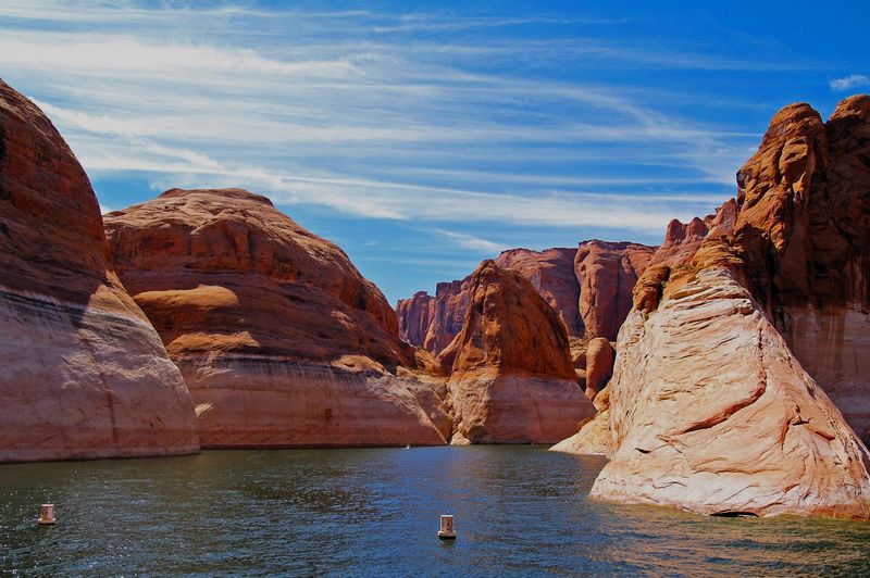
Antelope Canyon is the kind of place that stops photographers mid-step and leaves first-time visitors completely speechless. Located near Page in northern Arizona, this Navajo Nation land features two separate slot canyon sections — Upper Antelope Canyon, known as “The Crack,” and Lower Antelope Canyon, known as “The Corkscrew.” Both are stunning, but they offer distinctly different experiences worth exploring if time allows.
Upper Antelope is the more famous of the two, largely because of the light beams that pierce through narrow openings in the canyon ceiling during midday hours between late spring and early fall. These shafts of light illuminate the swirling sandstone walls in brilliant shades of orange, red, and gold, creating images that look almost digitally enhanced but are completely natural.
Tours are required to enter either canyon since the area is protected Navajo land.
Lower Antelope Canyon involves descending into the earth via metal staircases and navigating tighter passageways, which many visitors find even more adventurous than the upper section. Both canyons fill up quickly, especially during peak season, so booking a guided tour weeks in advance is strongly recommended.
Morning tours in Upper Antelope catch the best light beam action, making them the most sought-after slots available.