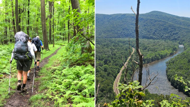
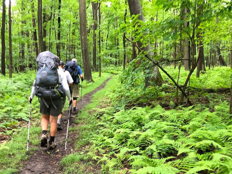
Stretching 70 miles through the rolling ridges of southwestern Pennsylvania, the Laurel Highlands Hiking Trail is one of the most rewarding long-distance trails in the entire state. Starting near Ohiopyle State Park, this trail winds through lush forests, past thundering waterfalls, and along high ridgelines with stunning views.
Whether you have a single afternoon or a full week, there is something here that will push your limits and reward every step. If you have ever wanted a trail that feels like a true adventure, this is the one to put on your list.
The 70-Mile Distance: What It Really Means for Hikers
Seventy miles sounds like a big number, and honestly, it is. The Laurel Highlands Hiking Trail runs from Ohiopyle State Park in Fayette County all the way north to the Conemaugh Gorge near Johnstown.
That kind of distance puts this trail in the same category as serious long-distance routes found across the entire country.
What makes this distance manageable for most hikers is the way the trail is divided. Eight overnight camping areas are spaced roughly eight to ten miles apart, meaning you can plan a multi-day backpacking trip without ever worrying about being too far from a safe resting spot.
Each shelter area has tent pads and a water source nearby.
Day hikers can also enjoy the trail by accessing one of several trailheads and tackling shorter sections. You do not need to commit to the full 70 miles to experience its beauty.
Some of the most scenic spots are reachable within just two or three miles of a parking area.
The elevation along the trail averages around 2,700 feet, which gives it a genuine mountain feel without requiring technical climbing skills. It is challenging enough to feel earned but accessible enough for motivated beginners.
Ohiopyle State Park: The Southern Gateway to the Trail
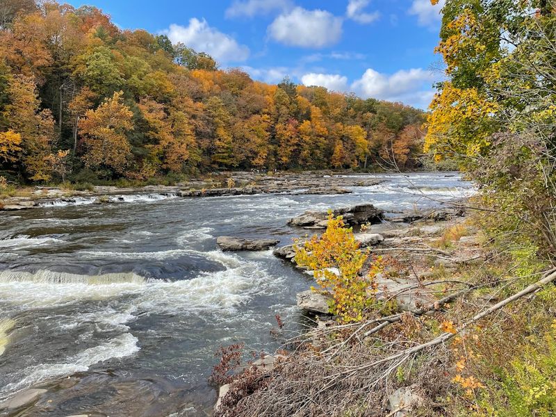
Few trailheads in Pennsylvania come with as much scenery as the southern terminus at Ohiopyle State Park. Sitting at the edge of the Youghiogheny River Gorge, this park is already a destination on its own before you even take your first step on the Laurel Highlands trail.
Ohiopyle is one of Pennsylvania’s largest and most visited state parks, covering over 20,000 acres. It draws whitewater rafters, mountain bikers, and nature lovers from across the Mid-Atlantic region every single season.
The town of Ohiopyle itself is a tiny, charming community that caters to outdoor adventurers with outfitters, food options, and gear rentals.
Starting your hike here means you get to experience the dramatic river gorge right from the beginning. The trail climbs quickly out of the valley, rewarding early effort with sweeping views back down toward the river and surrounding ridges.
That first climb sets the tone for everything ahead.
Parking at Ohiopyle is available near the visitor center, and rangers there can provide updated trail conditions, permit information for overnight camping, and helpful maps. Stopping in before you head out is always a smart move, especially for first-time visitors.
Waterfalls Along the Route: Cucumber Falls and Beyond
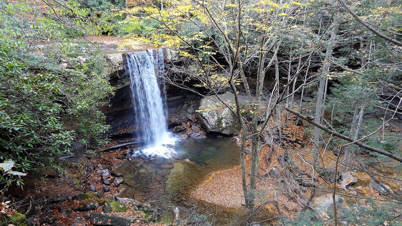
One of the first things hikers and visitors notice about the Ohiopyle area is just how many waterfalls exist within a short distance of each other. Cucumber Falls is probably the most famous, dropping about 30 feet into a rocky pool in a cool, shaded hollow just a short walk from the road.
Cucumber Falls is technically located in Cucumber Run Natural Area, which sits right inside Ohiopyle State Park. The trail to reach it is short and relatively flat, making it one of those rare spots where even non-hikers can experience something truly spectacular.
Kids especially love the mist and the sound of the falling water.
Beyond Cucumber Falls, the Laurel Highlands trail corridor passes near several other cascades and stream crossings that feel wild and remote. After a heavy rain, small seasonal waterfalls appear all along the slopes, turning the entire hillside into a network of rushing water.
It feels almost like hiking through a living landscape.
Waterfalls along this trail are not just pretty photo stops. They also signal healthy watersheds and clean stream ecosystems, which is something the Pennsylvania Department of Conservation and Natural Resources works hard to protect.
Take in the views, but always stay on marked paths near water edges.
Ridge Views That Stop You in Your Tracks
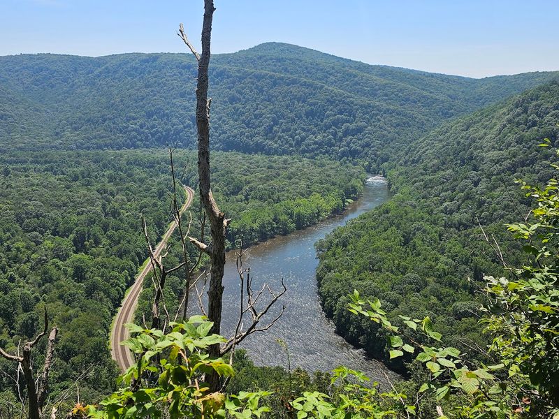
There is a particular moment on the Laurel Highlands Hiking Trail that almost every experienced hiker talks about: the first time the trees open up and you see the full sweep of the Laurel Ridge stretching out in both directions. It happens fast, and it never gets old.
The trail follows the spine of Laurel Ridge for a significant portion of its length, sitting at elevations that regularly top 2,500 feet. On clear days, you can see deep into Maryland and West Virginia from certain vantage points.
The views are especially dramatic in fall when the entire ridge turns shades of orange, red, and gold.
Unlike trails in the American West where rocky summits dominate the scenery, the Laurel Highlands offers a softer, more forested kind of ridge walking. The beauty here is in the layers, distant hills fading into haze, forests stretching unbroken for miles, and the occasional hawk riding a thermal overhead.
It feels peaceful in a way that is hard to describe.
Sunrise and sunset from the ridge are genuinely worth planning your schedule around. Arriving at a high point in the early morning hours, when mist still fills the valleys below, is an experience that makes the early alarm clock completely worthwhile.
Overnight Shelters and Backcountry Camping on the Trail
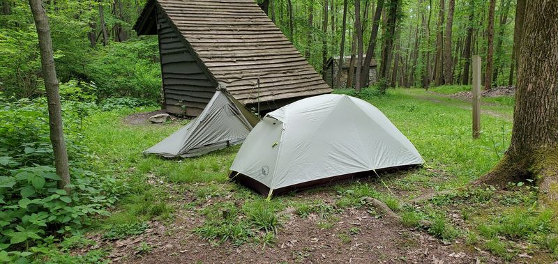
Backpacking the full length of the Laurel Highlands Hiking Trail requires a permit and a reservation at one of the eight designated overnight areas. This system keeps the trail from getting overcrowded and ensures every camper has a proper place to set up for the night.
Reservations can be made through the Pennsylvania State Parks online system.
Each camping area includes several tent pads, a pit toilet, and a nearby water source, though all backcountry water should be filtered or treated before drinking. The shelters themselves are three-sided wooden lean-tos that offer basic protection from wind and rain.
They fill up quickly on summer weekends, so booking early is genuinely important.
What makes overnight camping here special is the quiet. By late evening, when the day hikers have headed home, the trail belongs entirely to those who stayed.
Fireflies in summer, star-filled skies on clear nights, and the sound of wind moving through the trees create an atmosphere that feels completely removed from everyday life.
Fires are permitted in established fire rings at most shelter areas, but always check current fire restrictions before your trip. Carrying a lightweight camp stove is a smart backup plan regardless, since conditions can change and fire bans are sometimes issued during dry stretches.
Wildlife You Might Encounter Along the Way
The forests of the Laurel Highlands are alive in ways that most suburban hikers are not used to seeing. White-tailed deer are practically guaranteed sightings, especially in the early morning or evening hours when they move through the trees with surprising quietness.
Black bears also live throughout this region, and encounters, while not common, do happen.
Bird life along the trail is exceptional. The ridge acts as a natural corridor for migratory species, meaning spring and fall bring waves of warblers, raptors, and thrushes moving through the canopy.
Birders who time their visits with migration windows often describe the experience as overwhelming in the best possible way.
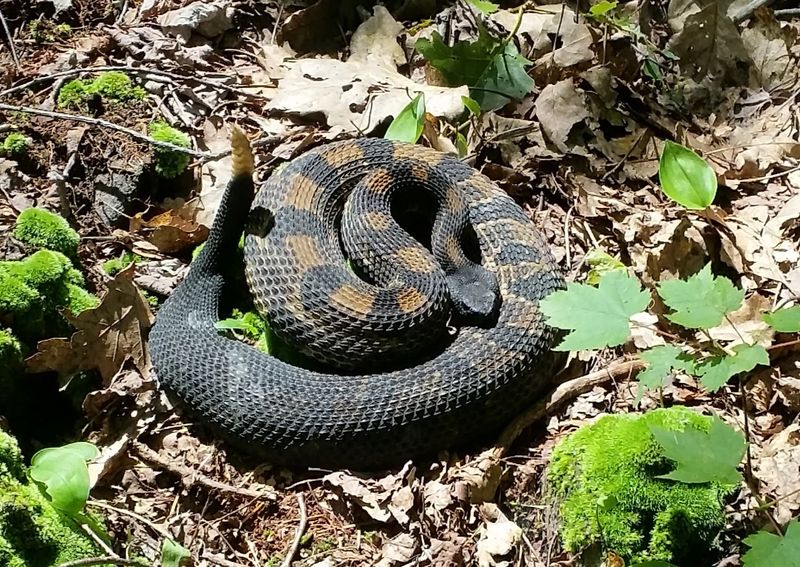
Timber rattlesnakes are native to this area and occasionally spotted on rocky outcroppings or sunny trail sections, particularly in warmer months. They are not aggressive animals, and giving them space and moving calmly past is all that is needed.
Most hikers never see one despite spending days on the trail.
Carrying bear spray is a personal choice on this trail, but storing food properly in a bear canister or hanging bag is not optional. The black bears here are wild animals that have learned to associate campsites with food, and keeping a clean camp protects both hikers and the bears themselves.
Trail Conditions and Best Times to Visit
Timing a trip to the Laurel Highlands Hiking Trail can make a huge difference in what you experience. Each season brings its own personality to the ridge, and knowing what to expect ahead of time helps you pack smarter and enjoy the journey more.
Spring is muddy but beautiful. Wildflowers blanket the forest floor in April and May, and streams run full and fast from snowmelt.
The downside is trail erosion and sections of deep mud that can slow progress significantly. Waterproof boots are not a suggestion in spring, they are a necessity.
Summer brings lush green canopy and warm evenings perfect for sitting outside a shelter, but also humidity, bugs, and the occasional afternoon thunderstorm. Carrying insect repellent and checking weather forecasts daily keeps the experience enjoyable rather than miserable.
Fall is widely considered the best time to hike the Laurel Highlands. Cooler temperatures, reduced bugs, and the explosion of autumn color across the ridge make October especially magical.
Winter hiking is possible for experienced hikers with the right gear, and snow transforms the landscape into something hauntingly quiet and beautiful. Snowshoes or microspikes are recommended from December through February.
The Youghiogheny River Gorge: A Natural Wonder Below the Trail
Before the Laurel Highlands Hiking Trail climbs into the ridges, it passes near one of Pennsylvania’s most dramatic natural features: the Youghiogheny River Gorge. Carved over thousands of years by the river cutting through layers of sandstone and shale, this gorge is a geological showpiece that draws attention from scientists and sightseers alike.
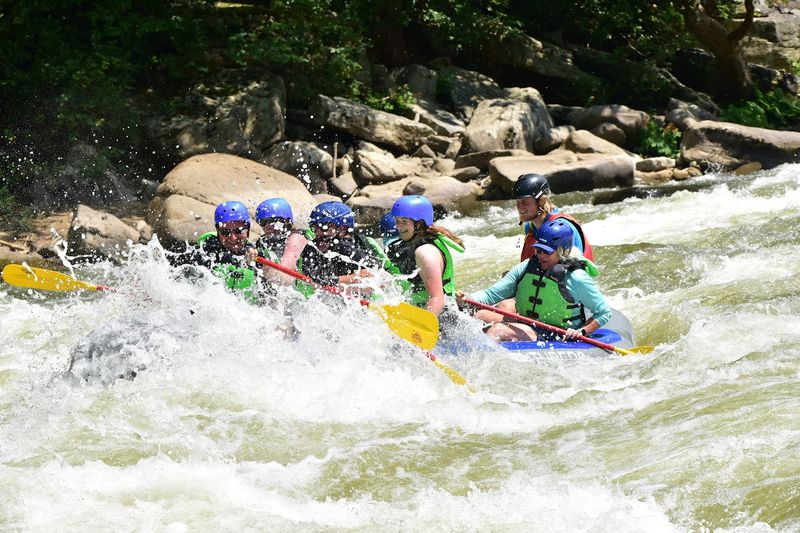
The river itself is famous for whitewater rafting, with Class III and IV rapids drawing paddlers from across the region every weekend from spring through fall. Watching rafters navigate the churning water from a high viewpoint above the gorge is genuinely exciting, almost like watching a sport from the best seat in the stadium.
The gorge also creates a unique microclimate that supports plant species not commonly found elsewhere in Pennsylvania. Ferns, mosses, and moisture-loving wildflowers thrive in the cool, damp air near the river.
Botanists and nature photographers make special trips here just to document the unusual plant communities growing along the canyon walls.
Standing at the gorge rim and looking down at the river twisting far below is one of those experiences that puts the scale of nature into sharp perspective. It is humbling in the best possible way, a reminder that some landscapes simply cannot be improved upon.
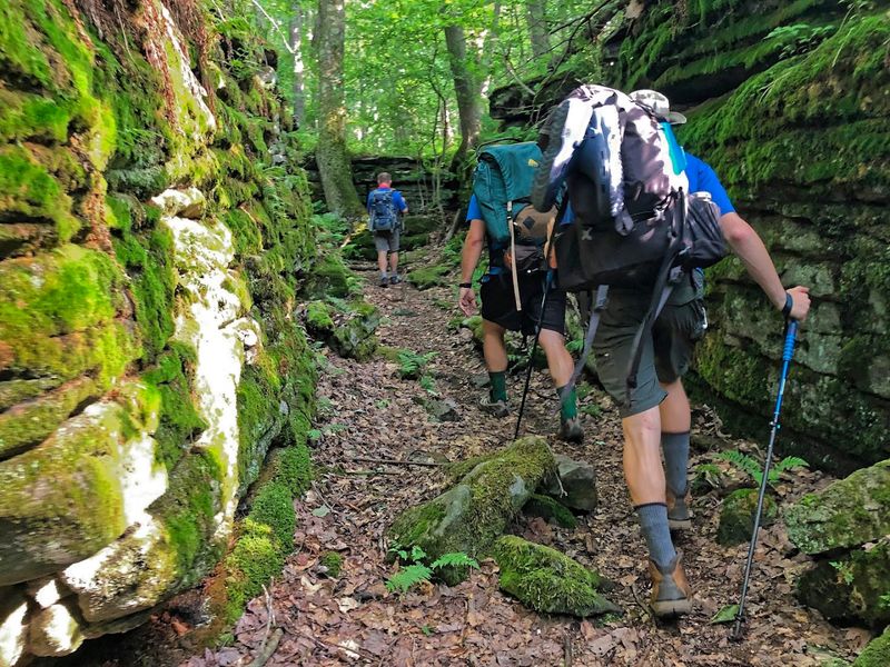
Gear Essentials and Trail Tips for First-Time Visitors
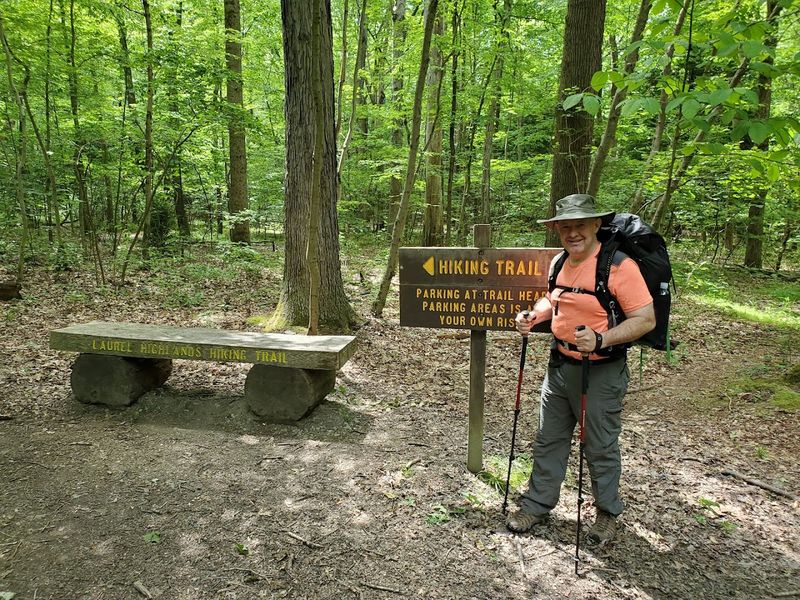
Showing up underprepared for the Laurel Highlands Hiking Trail is one of the most common mistakes first-time visitors make. The trail looks approachable on a map, but the combination of elevation, variable weather, and distance demands that you bring the right equipment from the very start.
Water is the most critical resource to manage. Natural water sources exist at all camping areas, but carrying a lightweight filter like a Sawyer Squeeze or a SteriPen means you never have to ration your supply between sources.
Dehydration on a ridge trail with no shade can turn a great day into a miserable one very quickly.
Navigation tools are equally important. The trail is blazed with yellow paint marks on trees, but carrying a paper map and a downloaded offline GPS track adds a meaningful safety layer, especially in sections where blowdowns or overgrowth can temporarily obscure the blazes.
Cell service is unreliable across large portions of the route.
Trekking poles are one of those items that hikers either love from day one or wish they had brought after the first steep descent. On a trail with as much elevation change as this one, poles reduce knee strain dramatically over multiple days.
Renting or borrowing a pair for your first trip is a low-cost way to find out if they work for you.