
It takes only a short drive away from Connecticut’s major highways to discover a quieter and more traditional pace of life.
Far from the noise of busy transportation corridors, historic river routes and estuaries continue to support communities whose history and daily routines remain closely tied to the water.
Areas once defined by shipyards, mills, and ferries that connected inland settlements to the Atlantic now feature working marinas, museums, waterfront parks, and preserved historic districts.
Rather than being reshaped by modern development, many of these towns have maintained a balance between natural landscapes and historic streetscapes.
The following guide highlights 12 riverfront towns in Connecticut that are especially well suited for a peaceful weekend escape.
These are places where relaxation is measured less by distance traveled and more by time spent along the water’s edge.
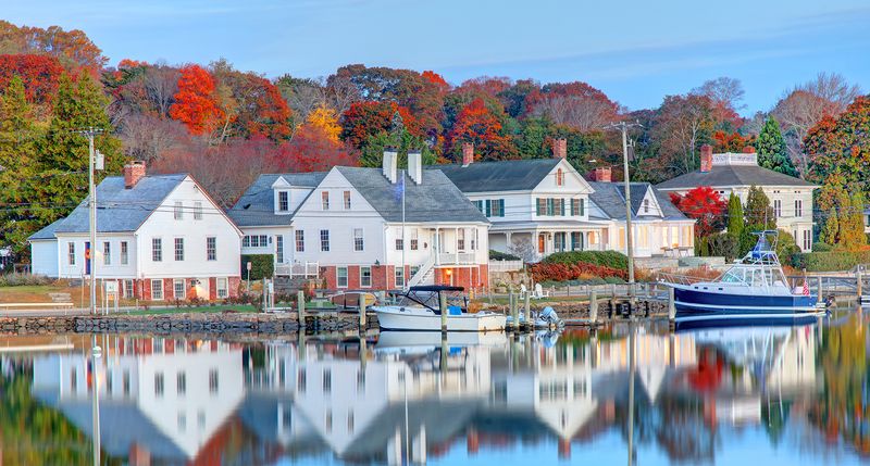
Essex
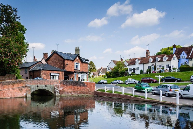
Set on a bend of the Connecticut River, this old seaport developed around shipbuilding, privateering, and Atlantic trade.
During the War of 1812, British forces raided the waterfront in 1814 and burned vessels, an event still remembered locally.
Federal and Colonial houses line Main Street and nearby lanes, showing how wealth from maritime commerce shaped the built landscape.
Down by the water, the Connecticut River Museum interprets regional river history and occupies a former steamboat warehouse.
Seasonal cruises aboard the Becky Thatcher let you read the shoreline from the deck, with marshes, coves, and broad tidal views explaining why navigation mattered here.
The Essex Steam Train also connects the village to the lower valley’s transportation story through historic rolling stock and a riverboat excursion.
Sailing remains part of everyday identity because deep water, protected landings, and yacht facilities still support small craft culture.
Instead of feeling frozen in time, the center works as a living waterfront where residents walk, dine, and gather near the docks. That combination gives the river a visible role in community life.
Old Saybrook

Where the Connecticut River meets Long Island Sound, geography dominates nearly every local story.
The wide estuary created a strategic colonial site, and English settlers established the Saybrook Colony here in 1635 near the mouth of a major transportation corridor.
Fort Saybrook once guarded this approach, showing how military concerns followed the same water routes used by traders and travelers.
Marinas, yacht clubs, and public shoreline areas still reveal that meeting point between river and sound. Fishing boats, tidal creeks, and broad marsh views give the waterfront a working feel rather than a purely scenic one.
At nearby Saybrook Point, the open horizon and changing currents make it easy to understand how navigation, storm exposure, and access to inland markets shaped local identity.
Farther inland, old streets and houses preserve links to the colonial period without separating history from present life.
Ferry roads, railroad connections, and harbor facilities once tied together coast and river communities, and those layers remain visible. Spending time here means reading the landscape as much as visiting individual landmarks.
Deep River
Along the lower valley, this hillside community looks modest at first, yet its history reaches far beyond its size.
During the nineteenth century it became known for ivory piano key manufacturing, part of a wider regional industrial network that depended on river access and imported materials.
That past still lingers in older commercial blocks, worker houses, and street patterns that follow the terrain above the water.
The center today is shaped less by grand monuments than by everyday local life.
Independent shops, restaurants, and civic spaces give the downtown an intimate scale, while nearby landings and back roads keep the river close without overwhelming the village core.
Because the surrounding landscape includes coves, wooded slopes, and tidal marshes, the setting feels tied to the broader Connecticut River Valley rather than cut off from it.
Community traditions matter here, especially events that bring residents into the center rather than dispersing them.
Historical memory is practical, not decorative, because it explains why industry emerged in a small place with strong water connections.
The result is a town where landscape, commerce, and neighborly routines still reinforce one another.
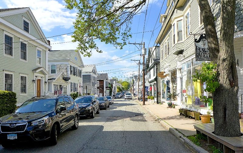
Chester
Unlike waterfront places built around large harbors, this village uses proximity to the river in a quieter way. Its compact center rises slightly inland, creating a walkable Main Street where historic buildings, galleries, and small businesses define the experience more than docks do.
That separation from the shore gives the place a distinct rhythm, with river access present but not visually dominant.
Nearby Chester Creek and the Connecticut River still shape the local environment through tidal influence, marsh habitat, and recreational access.
Residents can reach boat launches and natural areas without turning the downtown into a marine strip.
The famous Sunday market, local theater activity, and art spaces show how culture thrives within a preserved nineteenth century streetscape rather than in an isolated resort setting.
Architecture matters here because the scale stays human and the blocks remain easy to cross on foot. Trees, stone walls, and the surrounding valley soften the commercial district and connect it to the landscape.
That balance between village life and nearby water explains why the setting feels calm without feeling remote or museum-like.
Old Lyme
Few places in the lower river region show the link between landscape and culture as clearly as this one.
The area became famous through the Lyme Art Colony, where painters responded to meadows, changing light, and tidal scenery that still define the local environment.
At the Florence Griswold Museum, art history is inseparable from the surrounding grounds and the broader estuarine setting.
Wetlands and preserves are central to understanding the community, not simply background scenery.
The Connecticut River estuary supports migratory birds, salt marsh ecology, and conservation work that has shaped land use decisions for decades.
Sites managed by organizations such as the Lyme Land Conservation Trust help protect habitats that also preserve the visual character artists once found compelling.
Roads, houses, and public institutions sit within a region where environmental sensitivity remains unusually visible.
The nearby river, tributaries, and marshlands limit overbuilding and keep attention on seasonal change, water levels, and wildlife movement.
That ongoing relationship between ecology and creativity gives the town a cultural identity rooted in place rather than nostalgia.
Mystic
Centered on the Mystic River, this community grew through shipbuilding, coastal trade, and a maritime economy that tied southeastern Connecticut to global routes.
The river’s protected channel allowed yards to build and launch vessels, including the whaleship Charles W. Morgan, now preserved at Mystic Seaport Museum.
That institution remains one of the country’s most important places for interpreting seafaring labor, craft, and navigation.
The bascule drawbridge in the middle of the village reminds you that the waterway still structures daily movement.
Boats pass through a downtown lined with inns, shops, and restaurants, yet the setting keeps a working waterfront feel because marinas and marine services remain active.
Walks along the river reveal old wharf alignments, restored buildings, and a shoreline where tourism and boating continue to coexist.
Elsewhere, the Mystic River Bascule Bridge and nearby waterfront parks frame views toward the estuary and Long Island Sound.
Kayaking, sailing, and museum visits all make more sense when seen as parts of the same river system. Here, the water is not decoration but the reason the settlement developed at all.
Stonington Borough
At the tip of a narrow peninsula, this borough faces the harbor with unusual directness.
Streets end at water views, old houses stand close to one another, and the compact plan reflects a settlement shaped by fishing, trade, and defense.
During the War of 1812, local forces resisted a British attack in 1814, a moment preserved through monuments and public memory.
The harbor still supports commercial fishing and recreational boating, so maritime tradition remains visible in everyday routines.
From the old lighthouse museum to the seawall and breakwater views, the waterfront shows how people adapted to weather, tides, and a limited land area.
Architecture is especially important because eighteenth and nineteenth century homes survive in dense concentration, preserving the scale of an older coastal community.
Unlike larger resort oriented shores, this place feels organized around working water and long continuity. Lobster boats, small marinas, and harbor activity give the streets a practical edge beneath the polished historic appearance.
That tension between preservation and use helps explain why the borough still reads as a living New England port.
Niantic
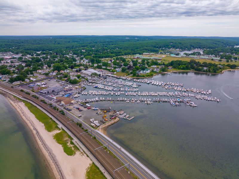
Bordered by the Niantic River and Long Island Sound, this shoreline center combines recreation with an older maritime identity.
The river’s coves and inlets helped sustain boating and shellfishing, while the protected water also encouraged marinas and small craft activity.
Geography matters here because the narrow downtown, beaches, and riverfront spaces sit close enough together to be explored on foot.
The Niantic Bay Boardwalk is one of the clearest examples of how public access shapes local life.
Built along the water beside the rail corridor, it gives residents and visitors a continuous path for walking, birdwatching, and reading the shoreline.
Nearby McCook Point Park and Hole-in-the-Wall Beach connect that walkway culture to swimming, picnicking, and everyday coastal use rather than formal sightseeing.
Shops, cafes, and service businesses along Main Street reinforce a slower pace because they serve a community scaled to pedestrians, boaters, and beachgoers.
Fishing traditions remain visible in tackle culture, dock activity, and the casual practical style of the waterfront. The overall effect comes from access and routine, not spectacle.
Haddam

Farther upriver, the landscape becomes more rural, and that shift is central to this town’s character.
Broad stretches of the Connecticut River meet wooded hills, farmland, and scattered historic houses, creating a settlement pattern that reflects older transportation limits.
Ferry crossings once mattered deeply here because they linked agricultural communities on opposite banks before bridges became common.
The Chester-Hadlyme Ferry, operating nearby since the nineteenth century, preserves that older river logic in a very direct way.
Rather than treating the water as an obstacle to speed past, the crossing turns travel into a short encounter with current, shoreline, and scale.
Eagle Landing State Park and other access points also emphasize outdoor recreation, from boating to seasonal bird observation along one of New England’s major tidal rivers.
Historic sites such as the Thankful Arnold House Museum help explain how colonial settlement adapted to topography and transportation.
Roads curve with the land, and village areas remain small because growth followed practical routes rather than speculative grids.
The result is a river town defined less by commerce than by landscape, memory, and movement across water.
East Haddam
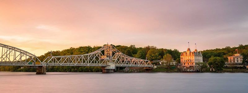
Perched above one of the most dramatic reaches of the Connecticut River, this town uses topography as part of its identity.
Steep wooded slopes, broad water views, and the narrow village setting create a sense of arrival that differs from flatter coastal places.
The East Haddam Swing Bridge, opened in 1913, remains a landmark because it physically and visually connects communities across the river.
Most attention goes to the Goodspeed Opera House, a restored Victorian theater that stands directly on the waterfront.
Its location matters as much as its architecture, since performances unfold beside a river that once carried goods, news, and travelers through the valley.
Nearby historic sites, including Gillette Castle State Park in the surrounding area, extend that cultural landscape into one shaped by cliffs, forest, and overlook views.
Outdoor recreation and heritage tourism meet here without canceling one another.
Hikers, paddlers, and theatergoers all encounter the same river corridor from different angles, which helps explain the town’s unusual coherence.
Water is the organizing presence, but elevation and scenery give that presence unusual force and drama.
Middletown
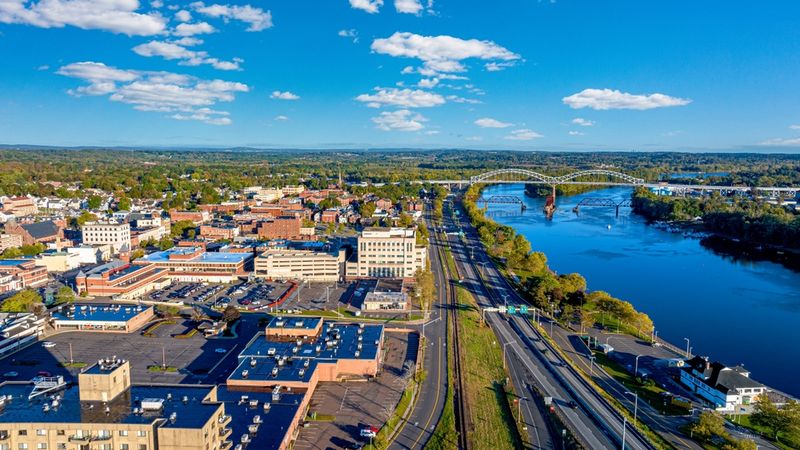
As a larger regional center, this city shows how river history can support urban development rather than village preservation alone.
The Connecticut River made it an important colonial port, and in the eighteenth and nineteenth centuries ships from here traded with the Caribbean and beyond.
Wealth from that commerce helped shape Main Street, where substantial commercial blocks and institutional buildings still express civic ambition.
Industrial growth later changed the waterfront, and modern revitalization has worked to reconnect the city with the river.
Harbor Park creates public access where infrastructure once kept the shoreline at a distance, making the broad channel visible again in daily life.
Wesleyan University also contributes to the cultural landscape through museums, performances, and historic architecture that reinforce the city’s role as an intellectual and artistic hub.
What stands out is the layering of eras within a relatively compact area.
Churches, civic buildings, row blocks, and riverfront spaces show how transportation, trade, and education combined to sustain a regional center.
The place feels different from smaller towns because the river here supported complexity, density, and long institutional continuity.
Windsor
Founded in the seventeenth century, this community is often cited as Connecticut’s first English settlement, and its river setting explains why.
The Connecticut River region offered fertile floodplain soils, access to Indigenous travel routes, and connections to other colonial outposts.
The nearby mouth of the Farmington River added another layer of movement, linking inland valleys to one of New England’s most important waterways.
Agriculture remained essential for generations because the surrounding land was productive and relatively easy to work.
Historic houses, burying grounds, and the broad town green preserve that early pattern of settlement, while the Windsor Historical Society interprets local life through architecture and material culture.
Here, colonial history is not abstract because the surviving landscape still shows how households, fields, roads, and meeting places related to water access.
The town differs from lower river ports because its identity rests less on maritime trade than on inland exchange and farming.
Yet waterways were still decisive, shaping property lines, transportation choices, and the placement of early institutions.
That makes the area important for understanding how river systems supported settlement far beyond the shoreline itself.